
The Caraway’s as they enter their final month of business. (William McPherson, Photo)
Benton, West Frankfort, Illinois News | Franklin County News
Newspaper covering Franklin County, Illinois
by Reece Rutland Rend Lake College Public Information
INA, IL
The longest serving president in Rend Lake College’s history also happened to be the first local product in the head office.
Ewing native Mark S. Kern was an instrumental part of RLC almost from the beginning, but it was his 17 years as president (1991-2008) of the institution that cement his legacy and earn him a spot on the 50 Influencers list.
Mark Kern, left, teaches two Agriculture students during the first years of Rend Lake College.
In total, Kern spent 40 years of his working life in the Illinois Community College System – longer than any employee in the history of the system, according to the Illinois Community College Trustees Association at the time.

Mark Kern as a teacher in the early days at Rend Lake College (All Photos are submitted by RLC)
He was hired in to help start the RLC Agriculture program and, played a major part in enrollment growth – from 765 students in 1968-69 to a fall 2003 record enrollment of 5,283. The Ag program even had to survive a tornado which destroyed its original facilities in Bonnie Grade School.
Joining RLC as an Agriculture Instructor in 1968, Kern moved up to Agriculture, Automotive and Architecture Department Chair two years later and became Dean of Community Services in 1974 and Dean of Instruction in August 1978. He was named RLC’s fifth President in 1991.
Kern, a Benton Consolidated High School graduate, left the family farm in Snowflake to pursue his Bachelor of Science Degree in Agricultural Industries at Southern Illinois University-Carbondale (1966). He continued his education at the University of Illinois, with a Master of Science Degree in Agricultural Economics (1968). When he went to college, he did so with the intentions of going into agricultural banking.
But, when the Wabash job came up, a young Kern thought he might like to try his hand at teaching.
He was appointed Interim President from March to June of 1989, filling the gap between the service of Dr. Harry Braun and Dr. Jonathan Astroth. Astroth submitted his resignation after two years to become the founding President of Heartland Community College in Bloomington, opening the way for Kern to vie for the leadership role.

Mark Kern as President of RLC
He officially took the president’s office effective Sept. 3, 1991.
“I am very excited and pleased about the opportunity ahead,” Kern told media shortly after he was voted into the top administrative position.
“I grew up in this area and that makes it even more special. I really believe this college has been a wonderful asset for this area. To be in a leadership role at the college is a great opportunity. Probably the biggest thing the college does for this area is provide a quality college education within driving distance of home for most of our students. Some people, if they weren’t able to attend college here, would not be able to go (to college) otherwise.”
Kern admitted he was eager when he began his new job.
“There are a lot of good people here to work with. I am looking forward to working with them and the challenges ahead,” he said following the vote.
During Kern’s tenure, several major projects were undertaken and executed. Some of the major highlights include:
“Thank you very much,” Kern said when it was revealed that the Applied Science Center would carry his name. “This comes as quite a surprise. It is greatly appreciated. I did not expect to have a building named after me . . . I am very humbled and very appreciative.”
Kern is one of only three individuals to have a college building dedicated to him.
The others are the Dr. Allen Y. Baker Administration Building after the founding Board of Trustees member, Pinckneyville optometrist and pillar of community service; and the James “Hummer” Waugh Gymnasium after the longtime coach, instructor and supporter of everything Rend Lake College.
Kern also played a major part in such accomplishments the various successful reaccreditation visits from the Higher Learning Commission, formerly the North Central Association of Colleges and Schools; recognition from the American Association of Community and Junior Colleges as one of the first three institutions honored nationally for Outstanding Service to Industry; establishment of a Community Coordinator system; the cooperative efforts between Franklin and Jefferson County 4-H programs and the Rend Lake Conservancy District in building shared facilities on campus, and the addition of many educational programs.
He was responsible for initiating the first Advisory Council – comprised of community leaders actively involved in various fields of agriculture who provided valuable input for college staff and programs – and Cooperative Education (on-job training) programs, both of which are still in existence for almost all career-technical programs, and introduced the Community Service / Community Education concept as Dean of Community Services.
As president, he was also instrumental in acquiring three different Federal Title III “Strengthening Institutions” Grants which netted the college approximately $5 million and brought drastic improvements in many areas, including fund-raising through the RLC Foundation, campus-wide computerization and the Wireless Communications program.
In May 2004, Kern became the first person to be recognized for 35 years of full-time service to Rend Lake College. The RLC Foundation Board of Directors also named Kern an Emeritus Member for his support to the organization over the years.
“There has been no one more instrumental in the growth of the Foundation than Mark Kern,” former RLC Foundation Chair Hunt Bonan said at Kern’s retirement. “When he became President, I think the Foundation had approximately $100,000 in assets. Today, we are proud to say, the Foundation has over $5 million in assets. That is a big number. But, more important is that last year the Foundation gave out over $300,000 in scholarships. That assists students in the district with coming to Rend Lake College; however in some cases, it meant the difference in whether a student would go to college or not. I think that is an amazing statement and the work Mark has done with the Foundation – his dedication and absolute tenacity in demanding the very best – has been so important for our growth . . . We hope he keeps promoting the Foundation because he is our best promoter in the community.”
He was inducted into the RLC Sports Hall of Fame class of 2008; Warrior/Lady Warrior athletics increased threefold while Kern was president.
“I have had a very rewarding career. You have to be fortunate to become a community college President, and becoming one in the area in which you grew up is even more special. I have been able to watch the college benefit people and the children of people I have known all my life,” Kern said during his final president’s address before his retirement on June 30, 2008.

Mark Kern at his retirement party
“I really believe the community college system has been the most exciting and most productive area of education during the last 40-plus years. I have been fortunate to have spent 40 years in that system. I won’t miss the night meetings or the trips to Springfield or Chicago. I have made friends with many fine people, including staff, Board members, Foundation Board members and other key people in the community. I will miss spending time with these people.”
“Thank you very much for the support you have given me, my family and Rend Lake College. Please keep providing that support to one of the finest educational institutions in the State of Illinois.”
Current RLC President and product of the Agriculture Program Kern helped build, Terry Wilkerson said of his predecessor, “It’s difficult to say enough about Mark. He always was and still is dedicated to Rend Lake College, and I believe the good of this place was first in his thoughts in the decisions he made here. He’s been a huge advocate for not only the college, but for college education in this area.”
Kern has been honored previously as the Franklin County 4-H “Outstanding Alumnus” and Franklin County Soil Conservation “Farmer of the Year” and was one of three Illinoisans selected for the Cooperative Extension Cow Tour in 1987. The Southern Illinois farmer-turned-RLC President was recipient of the 2001 Statewide Commercial Producers Award.
He also is a past Vice President and Secretary of the Illinois Council of Community College Administrators, a past member of the Benton Consolidated High School Board of Education and a past member of the Pastor-Parish Relations Committee and Administrative Board at First United Methodist Church in Benton.
Kern farmed in partnership with his father, Frank, for many years and presently owns and operates a 660-acre farm with 100 head of beef cows.
“Rend Lake College has met every challenge it has faced since 1967, and I am sure we will continue to do likewise in the future.”
by Steve Dunford –
The Flood Warning for Franklin County continues until 11:45 p.m. tomorrow for the entire county. I was anticipating this to be reduced to just the Big Muddy but the NWS is keeping it out one more day. All of the statements by the national weather service will be posted at the end of the story.
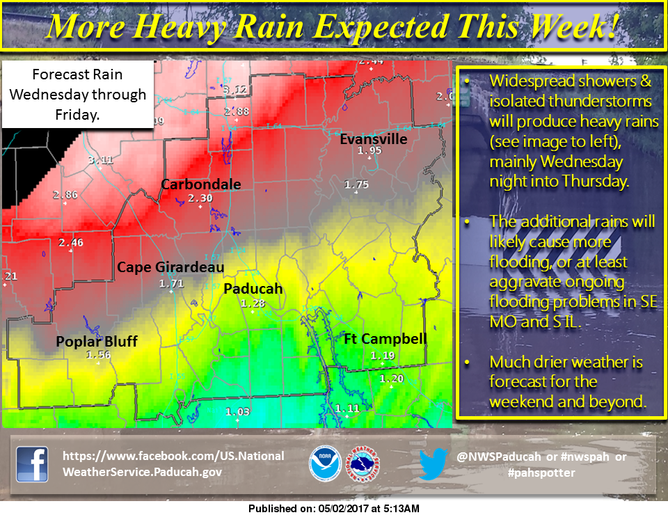
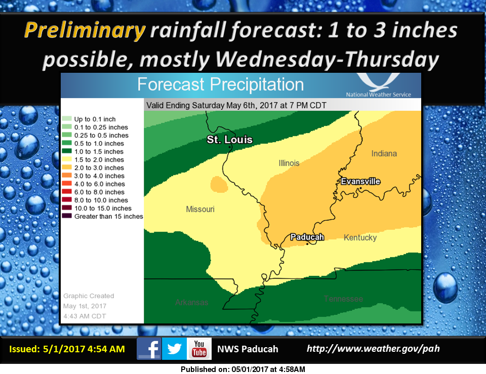
There is a Flash Flood Watch that will start on Wednesday morning into Thursday as heavy rains are forecasts.
Road Closures will be posted with the weather reports starting tomorrow unless the heavy rains start to hit us again.
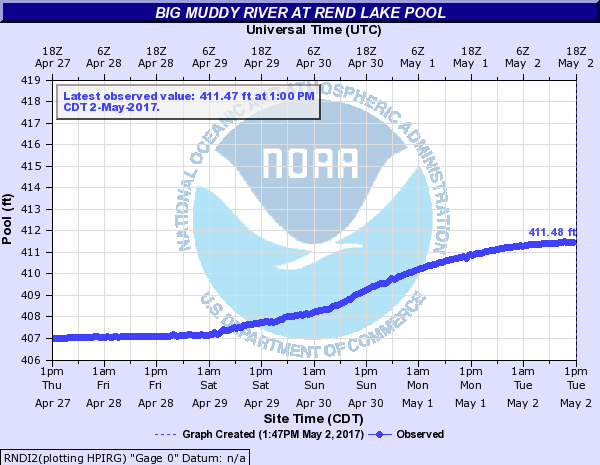
Above is the pool for Rend Lake today. Despite the high waters, a representative from the Army Corps of Engineers stated that South Sandusky and the bike trail below the dam in places is the only two facilities that are closed. There is a wind advisory for area lakes until 6:00 p.m.
He also said a loop of Wayne Fitzgerell campground was closed, he was unsure which one was. I could not make contact with the Illinois Department of Natural Resources. From past precedence, I would speculate it is Hickman Point and possibly the boat ramp.
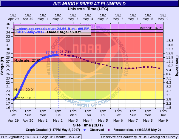
The Big Muddy River at Plumfield has crested. Today’s river stage forecast shows the river being in moderate flood stage longer than expected. There Mississippi is supposed to crest in Chester on Thursday on the , and as of now the bridge is still open. Near record crest are still in the forecast for Cape Girardeau and Thebes.
Here are statements that are issued by the National Weather Service in Paducah, KY.
FLOOD WARNING ENTIRE COUNTY
The National Weather Service in Paducah has extended the * Flood Warning for… Perry County in south central Illinois… Wayne County in south central Illinois… Williamson County in southern Illinois… Saline County in southern Illinois… Jackson County in southern Illinois… Franklin County in south central Illinois… Hamilton County in south central Illinois… * Until 1145 AM CDT Wednesday
* At 1123 AM CDT, numerous state and county roads in several of the warned counties remain flooded or impassable across much of Southern Illinois. Water has receded from several area roads, but several county and emergency management officials still request that the flood warning remain in place for public safety. Another round of rain is expected Wednesday and Wednesday Night and may lead to additional flooding.
FLOOD WARNING FOR THE BIG MUDDY
The National Weather Service in Paducah KY has issued a flood warning for the Big Muddy River near Plumfield and Murphysboro The Big Muddy River will continue to rise at Murphysboro Illinois with a crest of 39.8 feet on Thursday morning. Plumfield Illinois will crest this evening at 28.7 feet and then begin a slow fall.
PRECAUTIONARY/PREPAREDNESS ACTIONS… SAFETY MESSAGE… Never drive cars…trucks or sport utility vehicles through flooded areas. The water may be too deep to allow safe passage. Never allow children to play in or near flood waters. Stay tuned to NOAA Weather Radio or your local media for further statements and possible updated forecasts.
LAKE WIND ADVISORY
The National Weather Service in Paducah has issued a Lake Wind Advisory, which is in effect from noon today to 6 PM CDT this evening.
* WINDS…Will be sustained from 15 to 20 mph. Gusts will range from 20 to 30 mph. The strongest winds are expected over the Evansville Tri State.
* IMPACTS…The strong gusty winds will pose a hazard to small boat operators on area lakes and rivers. Flood recovery efforts will also be negatively impacted, especially where boats are needed for checking flooded property
PRECAUTIONARY/PREPAREDNESS ACTIONS… A Lake Wind Advisory indicates that winds will cause rough chop on area lakes. Small boats will be especially prone to capsizing.
HAZARDOUS WEATHER OUTLOOK
This Hazardous Weather Outlook is for portions of southern Illinois, southwest Indiana, western Kentucky, and southeast Missouri. .
DAY ONE…Today and Tonight Following the weekend heavy rainfall, flooding continues in parts of our region. Major to record flooding exists on smaller rivers, as well as the Mississippi River, in southeast Missouri and southern Illinois. Please check the latest flood statements and warnings for details. .
DAYS TWO THROUGH SEVEN…Wednesday through Monday River flooding will continue through next weekend. Some of the larger mainstem rivers such as the Mississippi River will rise throughout the week. Some of the smaller rivers will begin to recede Tuesday. Please check the most recent river flood statements for the latest forecast information.
A slight chance of thunderstorms is forecast for all or a portion of the area Wednesday and Thursday. Lightning and locally heavy rainfall will be the primary concerns. Rainfall well over an inch from Wednesday through Thursday may aggravate existing flooding or lead to new flooding, especially over portions of southern Illinois, southeast Missouri, and southwest Indiana.
FLASH FLOOD WATCH
The National Weather Service in Paducah has issued a * Flash Flood Watch for a portion of southern Illinois, including the following areas, Alexander, Edwards, Franklin, Gallatin, Hamilton, Jackson, Jefferson, Johnson, Perry IL, Saline, Union, Wabash, Wayne IL, White, and Williamson. * From Wednesday morning through Thursday evening *
Another weather system will bring an additional 1 to 3 inches of rain to parts of Southern Illinois. The Flash Flood Watch will include all of the counties in Southern Illinois, along and northwest of a line from Cairo, Dongola, Vienna, Shawneetown, and Mount Carmel Illinois. Numerous counties in Southern Illinois continue to experience flooding on some roadways and low lying areas. A brief period of heavier rain will be possible Wednesday morning, but the main threat for heavy rain will be Wednesday night into Thursday afternoon. Given the already saturated ground, rainfall will runoff into creeks and low lying areas faster. *
This additional rainfall will likely worsen already flooded areas in the watch area, as well as cause flood waters to rise in those areas that have seen water drain away on Monday and Tuesday. Repeat flooding of low lying and poor drainage areas will be possible and dangerous flash flooding on smaller creeks and streams will be likely.
PRECAUTIONARY/PREPAREDNESS ACTIONS… A Flash Flood Watch means that conditions may develop that lead to flash flooding. Flash flooding is a very dangerous situation. You should monitor later forecasts and be prepared to take action should Flash Flood Warnings be issued. &&
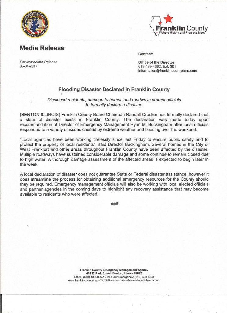
Media Release by Franklin County Emergency Management Agency Director, Ryan Buckingham
Press release from Congressman Mike Bost’s office

Rep. Bost speaks on behalf retired miners outside US Capitol (Photo provided)
WASHINGTON – U.S. Representative Mike Bost (R-Murphysboro) issued the following statement following the announcement that a permanent fix for miner’s health care benefits was included in the upcoming Fiscal 2017 spending bill:
“My colleagues and I made it abundantly clear to congressional leadership in recent weeks that another short-term extension of these vitally important health benefits for coal miners would be simply unacceptable. These men and women worked hard in extremely dangerous situations to power America and were made a promise. I am pleased that we have reached a long-term fix on the health care piece. This gives us operating room to continue working on a solution for pensions.”
by Steve Dunford
From this past weekends heavy rains, Morthland College received some damage to their campus this weekend. I spoke to Leigh Caldwell, who wears many hats for Morthland, and she said, “We have some water damage at Coleman Rhoads Hall, in the area that houses a handful of student services employees. They are being temporarily relocated. None of our classes are affected.”
This resulted in the postponement of the book sale at the school.
Here is some good news. The campus set a lofty goal for enhancing their library. The following statement was on their Facebook page:

Morthland college photo
If you hear Alpharetta chime 50 times on the morning of 5.1, don’t be alarmed; we’re just #forgingon. The Hall Snyder Library is officially at 50,082 books. Our campus goal of 50k by May has been reached!
We’ve got a bit of a problem, though. Our library stacks are quite literally in stacks on the floor! Help us finish raising the funds by the end of month fuve to build 15 more shelves.
Morthland College is a Chirstian based, non-denominational, liberal arts Chirstian college in West Frankfort. They offer a wide range of programs including athletics. Through their guilds, they have provided many jobs to the people of Franklin and surrounding counties.
by Steve Dunford
The Flood Warning for Franklin County has been extended until 5:45 this evening. The warning text will be included in the bottom of this post. There are several road closures in the county still. This has been posted on the website and the Facebook page.
Starting Tuesday night into the overnight hours on Friday Morning there are chances of rain. During this period, it is forecast that we will receive an additional 1-3 inches of rainfall. (see graphic above)
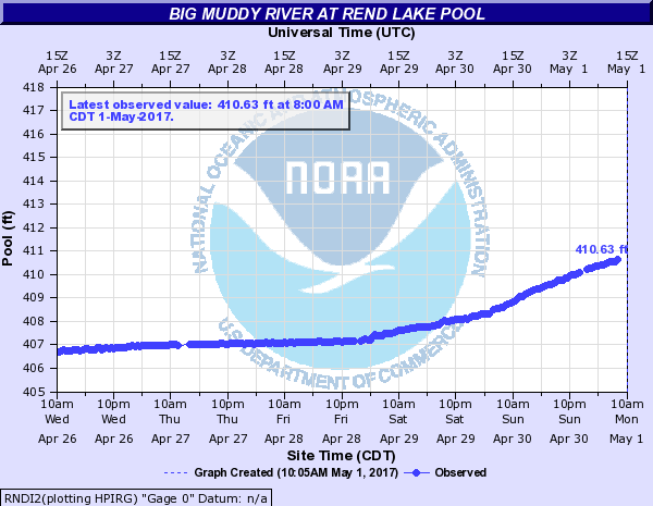
The water at Rend Lake is clearing the entire spillway, and not just the notch in the middle. (see graphic above) The water will do this at 410 feet. There is also a Lake Wind advisory for all of Southern Illinois. (advisory text below)
I will provide an update on facility closures. South Sandusky boat ramp is schedued to close sometime this evening.
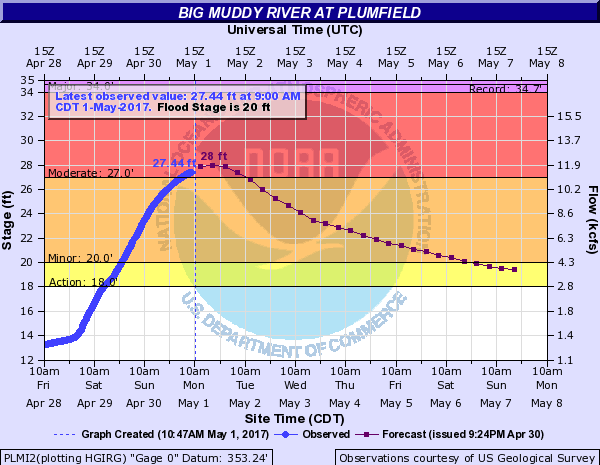
The Big Muddy at Plumfield is set to crest today at 28 feet in the moderate flood stage range. I spoke with Mary Lamm, Project Hydrologist at the National Weather Service in Paducah KY, and asked about the Big Muddy River and if the water released from Rend Lake will read on the automatic gauge there.
In our conversation she said that the gauge does compensate for it. She said that Rend Lake will affect the recession of the water that far down stream, but not add to the rise of it. River stage forecasts will include the additional rainfall projected starting tomorrow.
In some regional stages the Mississippi will crest in Chester at 43.5 feet on Thursday, which puts it in major flood stage. Several media outlets are sharing concern that the bridge will be closed there. There is only one lane open on the Missouri side. At Cape Girardeau the river will crest at 48.5 feet one-tenth above the record. It will also crest in Thebes on Saturday at 47 feet a few tenths below the record. All points on the Ohio, including Cairo are in moderate flood stage.
Here are the warnings and statements issued by the National Weather Service in Paducah KY.
FLOOD WARNING
The National Weather Service in Paducah has issued a * Flood Warning for… Perry County in south central Illinois… White County in southeastern Illinois… Wayne County in south central Illinois… Wabash County in southeastern Illinois… Jefferson County in south central Illinois… Edwards County in southeastern Illinois… Williamson County in southern Illinois… Saline County in southern Illinois… Jackson County in southern Illinois… Franklin County in south central Illinois… Hamilton County in south central Illinois… * Until 545 PM CDT Monday *
At 544 AM CDT, flooding continued in many areas. The threat for heavy rainfall is over. However, flooding along rivers, creeks and streams will continue, along with numerous water covered, flooded roads. There should be improvement in some areas. * Some locations that will experience flooding include… Carbondale, Marion, Mount Vernon, Herrin, Harrisburg, West Frankfort, Murphysboro, Mount Carmel, Benton, Du Quoin, Pinckneyville, Carterville, Carmi, Fairfield, Eldorado, Johnston City, McLeansboro, Christopher, Albion and Rend Lake Area.
PRECAUTIONARY/PREPAREDNESS ACTIONS… Turn around, don`t drown when encountering flooded roads. Most flood deaths occur in vehicles. Excessive runoff from heavy rainfall will cause flooding of small creeks and streams, country roads, farmland, and other low lying spots.
FLOOD WARNING FOR THE BIG MUDDY
…The flood warning continues for the following rivers in Illinois… Big Muddy River near Plumfield and Murphysboro .
The Big Muddy river at Plumfield is expected to crest this evening at 28.0 feet. It will start falling after that and should fall below flood stage on Saturday morning.
On the Big Muddy at Murphysboro… heavy rainfall…combined with backwater from the Misssissippi River… will continue to cause a rise this week. It will crest at 40 feet on Thursday…which puts us in the major flood category.
PRECAUTIONARY/PREPAREDNESS ACTIONS… SAFETY MESSAGE… Never drive cars…trucks or sport utility vehicles through flooded areas. The water may be too deep to allow safe passage. Never allow children to play in or near flood waters. Stay tuned to NOAA Weather Radio or your local media for further statements and possible updated forecasts.
HAZARDOUS WEATHER OUTLOOK
This Hazardous Weather Outlook is for portions of southern Illinois, southwest Indiana, western Kentucky, and southeast Missouri. .
DAY ONE…Today and Tonight Following the weekend heavy rainfall, flooding continues in parts of our region, mainly southeast Missouri and southern Illinois. Major to record flooding exists on smaller rivers in southeast Missouri and southern Illinois. Please check the latest flood statements and warnings for details. Gusty southwest winds from 15 to 25 mph are expected today, with gusts up to 35 mph this afternoon. A Lake Wind Advisory is in effect for today.
.DAYS TWO THROUGH SEVEN…Tuesday through Sunday River flooding will continue through next weekend. Some of the larger mainstream rivers such as the Mississippi River will rise throughout the week. Some of the smaller rivers will begin to recede Tuesday. Please check river flood statements. A chance of thunderstorms is forecast for all or a portion of the area Wednesday and Thursday. Lightning and locally heavy rainfall will be the primary concerns. Rainfall well over an inch from Wednesday through Thursday may aggravate existing flooding or lead to new flooding, especially over southern Illinois and southwest Indiana.
LAKE WIND ADVISORY
.Strong gusty southwest winds are expected today. These winds will be associated with the low pressure system that brought heavy rain and flooding to our region over the weekend.
The National Weather Service in Paducah has issued a Lake Wind Advisory, which is in effect from 7 AM this morning to 8 PM CDT this evening.
* TIMING…The strongest winds will occur from the late morning through the afternoon hours.
* WINDS…Southwest winds will increase to around 15 mph by mid- morning, then 20 to 25 mph for a few hours this afternoon. Gusts from 30 to 35 mph are likely this afternoon. Winds will decrease around sunset.
* IMPACTS…The strong gusty winds will pose a hazard to small boat operators on area lakes and rivers. Flood recovery efforts will also be negatively impacted, especially where boats are needed for checking flooded property.
PRECAUTIONARY/PREPAREDNESS ACTIONS… A Lake Wind Advisory indicates that winds will cause rough chop on area lakes. Small boats will be especially prone to capsizing.
by Steve Dunford
The flash flood threat is over. The National Weather Service in Paducah has issued a Flood Warning for all of Southern Illinois until 5:45 a.m. Monday Morning.
The difference between a Flash Flood Warning and a Flood Warning, a Flash Flood Warning is issued for an event that run off will be fairly quick. A Flood Warning is issued when there is sustained water. They are usually issued for rivers that are above flood stage. Issuing one for a widespread area, is unprecedented.
I am going to show a couple graphics, and at the end include the warning text. The first is the Big Muddy at Plumfield.
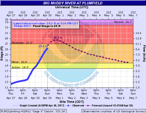
As you can see the Big Muddy has risen twelve feet over the last 48 hours. It should crest in the night and slowly recede below flood stage toward the end of the week. The NWS has severe flooding in the forecast for Murphysboro downstream, and possible record flooding might occur along the Mississippi at Cape.
I will keep a close eye on this for two reasons. First Rend Lake is getting ready to release a lot of water. Second there is 1-2 more inches of rain in the forecast from Tuesday night into Wednesday.
Here is a graphic for the headwaters at Rend Lake. 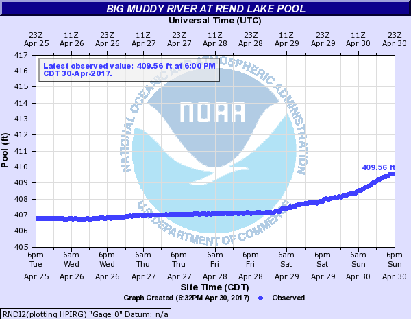
I spoke to a representative from the Army Corps of Engineers on Friday and they said that at 410′ water will go over the entire spillway. I will keep in contact with them for possible closure of facilities, and possible flooding on Rend City road. If water will go over the auxiliary spillway, Rend Lake Dam road might close.
Here is the full text for the Flood Warning:
The National Weather Service in Paducah has issued a * Flood Warning for… Perry County in south central Illinois… White County in southeastern Illinois… Wayne County in south central Illinois… Wabash County in southeastern Illinois… Jefferson County in south central Illinois… Edwards County in southeastern Illinois… Williamson County in southern Illinois… Saline County in southern Illinois… Jackson County in southern Illinois…
FRANKLIN COUNTY IN SOUTH CENTRAL ILLINOIS. Hamilton County in south central Illinois… * Until 545 AM CDT Monday * At 538 PM CDT, flooding continued in many areas. The threat for heavy rainfall is over. However, flooding along rivers, creeks and streams will continue, along with numerous water covered, flooded roads. The dangers will increase tonight as the dangers of flooding become harder to recognize. * Some locations that will experience flooding include… Carbondale, Marion, Mount Vernon, Herrin, Harrisburg, West Frankfort, Murphysboro, Mount Carmel, Benton, Du Quoin, Pinckneyville, Carterville, Carmi, Fairfield, Eldorado, Johnston City, McLeansboro, Christopher, Albion and Rend Lake Area.
PRECAUTIONARY/PREPAREDNESS ACTIONS… Turn around, don`t drown when encountering flooded roads. Most flood deaths occur in vehicles. Be especially cautious at night when it is harder to recognize the dangers of flooding. Excessive runoff from heavy rainfall will cause flooding of small creeks and streams, country roads, farmland, and other low lying spots.
