Goold: Wainwright gives prospect Sherriff a license to drive

Cardinal lefthander Ryan Sheriff who pitcher Adam Wainwright rented a vehicle for to get back and forth to the spring training complex.  (Chris Lee-  St. Louis post dispatch photo)

Cardinal lefthander Ryan Sheriff who pitcher Adam Wainwright rented a vehicle for to get back and forth to the spring training complex. (Chris Lee- St. Louis post dispatch photo)

JUPITER, FL (Derek Goold – St. Louis Post Dispatch- Click to read the full story. Here is an excerpt ) Cardinals lefty Ryan Sherriff has not had the photo on his driver’s license changed since he was 16 years old, and he adores it still because “it is probably the ugliest picture known to man.” So when a team employee came to him Wednesday and asked repeatedly for it, he immediately became suspicious. There had to be a prank afoot. He spent most of the game waiting for the picture from his license to pop up on the scoreboard, or to appear somewhere else that would get a laugh. “I’m just hanging out, didn’t know anything,” Sherriff said. “Everyone was asking me, ‘What is going on? Did you get drug-tested or something? Are you getting traded or something?’ I started putting things together.”

“She said yes!”

Taryan Ashli being proposed to by West Frankfort firefighter Matt Morthland

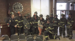
Taryan Ashli being proposed to by West Frankfort firefighter Matt Morthland (William McPherson – West Frankfort Gazette Photo)

WEST FRANKFORT, IL – (William McPherson – West Frankfort Gazette. Please click to read the full story. Here is an excerpt) – Sirens blazed as fire engines and other emergency vehicles descended upon West Frankfort City Hall last Friday. What was the occasion for such a grand display? A marriage proposal, of course. New West Frankfort Firefighter Matt Morthland proposed to his girlfriend, now fiancé, Taryn Ashli, who works at City Hall. “I was in shock. I had no idea,” Ashli added. “They pretended the building was on fire. I wasn’t scared. I was like, I don’t even see any flames, but they were telling me we had to leave the building.” Their response time for the call was under ten seconds, according to Mayor Tom Jordan and Chief Jody Allen.

Families rebuild as NWS tracks Franklin County tornado

One of the three destroyed homes in Franklin County from last night's tornado.  (WPSD-TV photo)

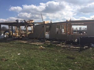
One of the three destroyed homes in Franklin County from last night’s tornado. (WPSD-TV photo)

MULKEYTOWN, IL- (Ashley Sanchez, WPSD-TV. Click to read the entire story and video. Here is an excerpt.) The National Weather Service rates the tornado that touched down in part of southern Illinois as at least an EF-3. An EF-5 is the strongest. The NWS says it was part of a storm that started in Springfield, Missouri, and ended in Indiana. A tornado touched down in Franklin County, Illinois, where It destroyed three homes. No one was injured. A NWS surveyor says the tornado touched down Tuesday night between Royalton and Mulkeyyton, Illinois. The tornado destroyed Shannon Parvin’s barn. “We heard a bunch of wind. It sounded like hail when we was in the basement. It took the barn, and it was gone,” Parvin said.

Day Tours making stops in St. Louis, St. Charles, Southern Illinois

INA, IL– Join Rend Lake College’s Community and Corporate Education Division this spring on three day tours through St. Louis, St. Charles, and Southern Illinois. Each trip offers participants the chance to see unique sides of these local sites.

In April, enjoy a Taste of St. Louis with stops at several popular restaurants and cafés. Begin at Gus’s Pretzels and Urzi’s Italian Market to pick up treats such as pretzels, cheese, and pepperoni. The tour will also stop at the Missouri Baking Company to partake of homemade cookies. Lunch will be at Pappy’s Smokehouse for a buffet of pulled pork, beef brisket, pulled chicken and much more. After lunch, enjoy dessert at the Chocolate Chocolate Chocolate Factory and Ted Drewes Frozen Custard.

The Taste of St. Louis tour costs $113, and is scheduled for Tuesday, April 18. Tour fees, samples at all locations, lunch, gratuities and charter bus transportation are included. Pre-registration is required by Monday, March 20. The bus departs from the Ina campus at 7:30 a.m. and will return by 6:30 p.m. The bus also stops at the RLC MarketPlace at 8 a.m. with a return time of 6 p.m.

Also in April, explore the wonders of Southern Illinois with a tour of the Ancient Native American World. Kick off the day with lunch at Giant City Lodge for the famous family-style dinner. After lunch, dive into the ancient Native American world with the Environmental Education staff at Southern Illinois University’s Touch of Nature Environmental Center for a presentation about the pre-Columbian occupation of Southern Illinois. Discussion of cultural periods and peoples, regional sites to visit, and connecting to ancient peoples through experimental archaeology will be covered, including a demonstration of making yucca cordage.

The Ancient Native American World tour costs $69, and is scheduled for Thursday, April 6. Lunch, gratuities, presentation fee and charter bus transportation are included. Pre-registration is required by Thursday, March 23. The bus departs from the Mt. Vernon MarketPlace at 9:45 a.m. and will return by 5:30 p.m. The bus also stops at main Ina campus at 10 a.m. with a return time of 5 p.m.

The final trip will put participants in the shoes of a famous folk hero during the Daniel Boone Home & Historic St. Charles tour. Start the day on historic Main Street in St. Charles as a costumed guide provides a tour of the cobblestone street and stops in several quaint shops along the way. Enjoy lunch at the Mother-In-Law House, featuring their famous homemade soup, salad and chicken salad bar. After lunch, journey back in time to relive the adventures of American longhunter Daniel Boone. Visit the home where he lived and learn the history of this legendary pioneer.

The Daniel Boone Home & Historic St. Charles tour costs $109, and is scheduled for Thursday, May 18. Tour fees, lunch, gratuities, and charter bus transportation are included. Pre-registration is required by Monday, April 3. The bus departs from the Ina campus at 7:30 a.m., and will return by 6:30 p.m. The bus also stops at the RLC MarketPlace at 8 a.m. with a return time of 6 p.m.

To learn more about this class, or any others this spring, call 618-437-5321, Ext. 1714. Pre-registration may be done in person, via phone call, or by emailingcommcorped@rlc.edu.

Christopher falls to Gallatin County on a Ramsey buzzer beater

NORRIS CITY – (Harrisburg Daily-Register Click on the link to read the full story. Here is an excerpt) Seth Ramsey scored 28 points including a game-winner in the final seconds of Gallatin County’s 42-40 win over Christopher at the NCOE 1A sectional semifinals Tuesday night. The win for the Hawks (21-8) means the school is into the Sweet 16 and will meet either Meridian or Woodlawn in Friday night’s sectional final. Ramsey scored the first 10 points out of the gate for his team which was deadlocked with the Bearcats (17-13) after eight minutes. After Gallatin County had built a 17-12 lead midway through the second quarter, Christopher then went on an 8-2 run before halftime to grab a 20-19 lead at the break.

Rural Crossville man killed in last night’s storms

Home where man was killed in rural White County in last night's storms.  (WFIE photo)

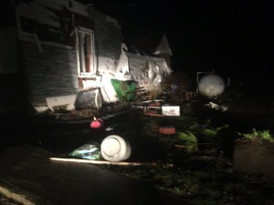
Home where man was killed in rural White County in last night’s storms. (WFIE photo)

CROSSVILLE, IL- (WFIE -TV Evansville, IN. Please click to read the story and the accompanying video. Here is an excerpt) There is widespread storm damage in the Tri-State. Mobile users click here to see a slideshow of damage pictures. In Crossville, Illinois, crews have found the body of a man who went missing after the storms. Deputies were looking for Tom McCord in a field off CR 1800 North. They say his house is destroyed, and his wife was taken to the hospital.

Severe Weather Preparedness- IEMA brochure

IEMA LOGOPlease view this pamphlet from Illinois Emergency Management Agency to go over as a severe weather checklist.  It is 15 pages long.  We have the potential to experience hail, high winds, and tornadoes tonight.  


TORNADO WATCH #41 ISSUED FOR FRANKLIN COUNTY

Tornado watch 41
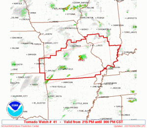
TORNADO WATCH OUTLINE UPDATE FOR WT 41 NWS STORM PREDICTION CENTER NORMAN OK 215 PM CST TUE FEB 28 2017 TORNADO WATCH 41 IS IN EFFECT UNTIL 900 PM CST FOR THE FOLLOWING LOCATIONS ILC003-005-013-027-047-051-055-059-061-065-069-077-081-083-087- 117-119-121-127-133-135-145-151-153-157-163-165-181-185-189-191- 193-199-010300- /O.NEW.KWNS.TO.A.0041.170228T2015Z-170301T0300Z/ IL . ILLINOIS COUNTIES INCLUDED ARE ALEXANDER BOND CALHOUN CLINTON EDWARDS FAYETTE FRANKLIN GALLATIN GREENE HAMILTON HARDIN JACKSON JEFFERSON JERSEY JOHNSON MACOUPIN MADISON MARION MASSAC MONROE MONTGOMERY PERRY POPE PULASKI RANDOLPH SALINE ST. CLAIR UNION WABASH WASHINGTON

First Alert Action Day issued this afternoon-Wed. morning due to threat of severe weather

First Alert(KFVS- TV Cape Girardeau, MO) NOTE-The potential for severe weather has taken a turn for the worse. This is a situation to be very concerned with. The hail and tornado threat has increased from the previous post that I shared about four hours ago. This is a situation that needs to be taken serious. Please check the website’s Facebook page for frequent updates of watches and warnings and other information leading to this event.

Keep your eye to the sky-especially during the overnight hours

Enhanced 2-28

This is the first of three Storm Prediction Center graphics I am sharing.   This one means there is a 10% chance of having a tornado 25 miles in any point of the yellow.  The hatch marks represent the potential of tornadoes being an F-2 or greater.

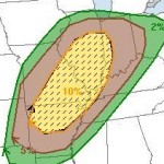
This is the first of two Storm Prediction Center graphics I am sharing. This one means there is a 10% chance of having a tornado 25 miles in any point of the yellow. The hatch marks represent the potential of tornadoes being an F-2 or greater.

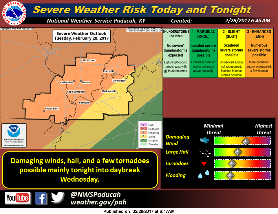
The threat of severe weather for tonight has been discussed for the last 48 hours or so.  Most of the models that I have looked at this morning will show some cells that will from in front of the main squall line after dark.  Most models show the squall line coming through around 3:00 a.m. tomorrow morning.

Those cells that form in front of the line

he TORCON values for toinght shows a 40% chance of receiving Tornadic Activity 50 miles or less from Franklin County (Dr Greg Forbes- The Weather Channel.)

The TORCON values for toinght shows a 40% chance of receiving Tornadic Activity 50 miles or less from Franklin County (Dr Greg Forbes- The Weather Channel.)

have the potential to become super-cells with the greatest risk of any tornadic activity in front of the line.

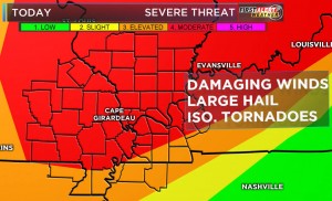
The greatest threat in the squall line will bed damaging thunderstorm winds.  Large hail and an inbedded Tornado can not be ruled out.

I am not saying things to alarm anyone, or scare anyone.  This system really had my attention since about mid day yesterday.

The second of three graphics from the SPC.  There is a 30% chance of seeing a severe wind event (60+ mph) 25 miles from Franklin County tonight.  The same percentage exists for quarter size hail or greater.

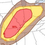
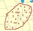
The is the second graphic from the SPC. There is a 30% chance of seeing a severe wind event (60+ mph) 25 miles from Franklin County tonight. The same percentage exists for quarter size hail or greater.

The potential does not mean it is going to happen, however preparedness is vital in an actual event.

Soon, there will be a Tornado preparedness guide posted on the website produced by FEMA, that Franklin County Emergency Management Agency Director Ryan Buckingham posted through the agency’s media sources.  Please review this for a refresher.

As long as there is a severe weather threat for Franklin County,  I will be up all night monitoring the situation to keep you informed.  Warnings from 75-100 miles out that any part of the county is potentially in the path of the storm, will be posted on the franklincounty-news.com’s Facebook page.  There will be updates on the website from time to time however.

Benton, West Frankfort, Illinois News | Franklin County News