Football Rules Changes – 2017

From the National Federation of High Schools

1-3-1h (NEW): Added that commercial advertising is not permitted on the ball.

Rationale: The ball cannot have commercial advertising added to the surface. The only permissible items on the ball are the ball manufacturer’s name and/or logo; school name, logo and/or mascot; conference name and/or logo; state association name and/or logos; and NFHS name and/or logos.

1-5-1b(3): Further clarifies that the jersey of the home team shall be a dark color clearly contrasting to the white jersey required for the visiting team.

Rationale: Home game jersey specifications were further revised to provide schools and manufacturers additional clarification regarding the current trend of utilizing lighter gray shades. The implementation date of 2021 affords schools and manufacturers the opportunity to ensure that newer dark-colored jerseys will clearly contrast with white jerseys. The requirement for contrasting colors to white is not a new rule, and this new clarification will allow changes to be made during normal replacement cycles.

1-5-1a(2) NOTE, 1-5-4: This change now permits any of the game officials to accompany the referee to meet with the head coach for equipment verification.

Rationale: Member state associations may determine the game official who is to accompany the referee during the required pre-game meeting with each head coach.

2-3-10 (NEW), 9-4-3n (NEW), 9-4 PENALTY: Added a new definition for a blindside block and specifies a penalty for an illegal blindside block.

Rationale: Continuing with the focus on risk minimization, the committee created a definition for a blindside block. This block involves contact by a blocker against an opponent who, because of physical positioning and focus of concentration, is vulnerable to injury. Unless initiated with open hands, it is a foul for excessive and unnecessary contact when the block is forceful and outside of the free-blocking zone.

2-16-2h: Clarified that illegal participation fouls by the receiving team occurring during the kick are now enforced under post-scrimmage kick fouls.

Rationale: Illegal participation fouls by the receiving team occurring during the kick are now enforced under post-scrimmage kick fouls. Illegal substitution and illegal participation fouls by the receiving team occurring at the snap continue to be enforced from the previous spot.

2-24-10 (NEW), 6-1-11 (NEW), 6-1 PENALTY: Added a new definition for a pop-up kick and specifies a penalty for a pop-up kick.

Rationale: Continuing with the committee’s efforts to minimize risk, a pop-up kickoff has been defined. A pop-up kick is a free kick in which the kicker drives the ball immediately to the ground, the ball strikes the ground once and goes into the air in the manner of a ball kicked directly off the tee. Such kicks will be penalized as a dead-ball free-kick infraction.

2-32-16: Expands the definition of a defenseless player by incorporating specific examples.

Rationale: The committee adopted specific examples of a defenseless player. By adding these examples, the committee continues to focus on risk minimization and responded to requests on the annual NFHS football rules questionnaire from participating coaches, game officials and state association representatives.

3-4-7 (NEW): Added a new option to the offended team to start the clock on the snap for an accepted penalty inside the last two minutes of either half.

Rationale: The committee added an option for the offended team on an accepted penalty inside the last two minutes of either half. The referee continues to have the authority to start or stop the clock if a team attempts to conserve or consume time illegally.

4-2-2l (NEW): Specifies that the ball is declared dead if a prosthetic limb comes completely off the runner.

Rationale:  With this change, the ball becomes dead when a prosthetic limb comes completely off the runner.

7-1-6: Now stipulates that it is encroachment to strike the ball or the snapper’s hand/arm prior to the snapper releasing the ball.

Rationale: Defensive players are restricted from contacting the ball or the snapper’s hand(s) or arm(s) until the snapper has released the ball.

7-5-10: Removes non-contact face guarding from the pass interference restrictions.

Rationale: This change eliminates the previous foul for non-contact face guarding forward-pass interference.


2017 EDITORIAL CHANGES

Facilities Statement; 1-3-2; 1-5-1a(1); 1-5-1a(2) NOTE; 1-5-2b; 1-5-3b(6); 1-5-3c(2); 1-5-5; 1-6-1; 1-6-2; 2-5-3; 2-41-3; 2-41-5; 3-4-8; 3-5-7f; 3-5-8b(2); 3-5-10b; 3-5-10c; 4-2-2k; 7-5-6a; 9-3 PENALTY; 9-4-3k; 9-8-1h; 10-5-1c; FOOTBALL FUNDAMENTALS – VI-2; PENALTY SUMMARY; INDEX.


2017 POINTS OF EMPHASIS


  1. Responsibility on Players to Avoid Illegal Contact
  2. Illegal Helmet Contact
  3. Sideline Management and Control, Professional Communication Between Coaches and Game Officials
  4. Proper Enforcement of Penalties for Violations of the Equipment Rules

Ewing High School “Warriors”

http://www.illinoishsglorydays.com/id605.html

EWING, IL  –  (Illinois High School Glory Days.  Please click on the link above for the full story.  Here is an excerpt below.)

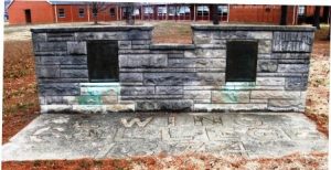
The cornerstone of Willard Hall, which sits in front of where the Ewing-Northern grade school is today. (James Horaz, Illinois High School Glory Days photo.)

Ewing (population 310) is located in far south central Illinois in the northeast portion of Franklin County.  Ewing is situated about 6 miles northeast of Benton.  County Highway 1 is the main roadway to and from Ewing and connects it to Illinois Route 37 just three miles to the west.  Interstate Highway 57 lies just to the west of Route 37.  Rend Lake is about four miles west of Ewing as well. 

A nice history of the town of Ewing was found at the web address of http://www.lib.niu.edu/ipo/1995/ihy951223.html.  In summary, this article states that Ewing was established in the mid-1800s and was a basic rural Illinois community. The early 1860s brought some prominent local men together who decided the area needed a high school.  In 1867 Ewing High School was established.  This was a pretty forward-thinking view at the time as most rural communities simply established a school for grades 1 – 8 and did not establish a high school until years later.  
Soon after the establishment of the high school the local people discovered their high school was not legally recognized.  These folks took things one step further, they decided to establish a college.  Ewing College was established in this very rural setting and attracted many more people and businesses to the area.
The population of Ewing rose to about 1,000 residents in the early 1900s, with the college enrollment a steady 300 students.  World War I and economic hardships caught up with Ewing College.  The school was closed in 1927 leaving the townspeople with heavy hearts.

Prep Football: Bartok takes part in Blue-Gray Combine in Florida

http://www.dailyregister.com/sports/20170627/prep-football-bartok-takes-part-in-blue-gray-combine-in-florida

HARRISBURG, IL-  (Michael Dann, Harrisburg Daily Register.  Please click on the link for the full story.  Here is an excerpt below.)

One foot in front of the other. That’s how Jordan Bartok feels about his journey to get to the next level in his football career.

The 6-foot-1, 220-pound Harrisburg High School senior took another step forward in that process as he recently took part in the Blue-Gray Super Combine at Spec Martin Memorial Field in DeLand, Florida.

The combine, which resembles the NFL combine, but for prep athletes, judges players on their 40-yard dash time, vertical jump, broad jump and how many reps they can bench at 185 pounds, as well as, a 1-on-1 passing drill.

2016 Perry County Final Multiplier Announced

SPRINGFIELD, IL, – Perry County has been issued a final property assessment equalization factor of 1.0000, according to Constance Beard, Director of the Illinois Department of Revenue.

The property assessment equalization factor, often called the “multiplier”, is the method used to achieve uniform property assessments among counties, as required by law. This equalization is particularly important because some of the state’s 6,600 local taxing districts overlap into two or more counties (e.g. school districts, junior college districts, fire protection districts). If there were no equalization among counties, substantial inequities among taxpayers with comparable properties would result.

Under a law passed in 1975, property in Illinois should be assessed at one-third (1/3) of its market value. Farm property is assessed differently, with farm homesites and dwellings subject to regular assessing and equalization procedures, but with farmland assessed at one-third of its agriculture economic value. Farmland is not subject to the state equalization factor.

Assessments in Perry County are at 33.29 percent of market value, based on sales of properties in 2013, 2014, and 2015.

The equalization factor currently being assigned is for 2016 taxes, payable in 2017. Last year’s equalization factor for the county was 1.0000.

The final assessment equalization factor was issued after a public hearing on the tentative factor. The tentative factor issued in May 2017 was 1.0000.

The equalization factor is determined annually for each county by comparing the price of individual properties sold over the past three years to the assessed value placed on those properties by the county supervisor of assessments/county assessor.

If this three-year average level of assessment is one-third of the market value, the equalization factor will be one (1). If the average level of assessment is greater than one-third of market value, the equalization factor will be less than one (1). And if the average level of assessment is less than one-third of market value, the equalization factor will be greater than one (1).

A change in the equalization factor does not mean total property tax bills will increase or decrease. Tax bills are determined by local taxing bodies when they request money each year to provide services to local citizens. If the amount requested by local taxing districts is not greater than the amount received in the previous year, then total property taxes will not increase even if assessments increase.

The assessed value of an individual property determines what portion of the tax burden a specific taxpayer will assume. That individual’s portion of tax responsibility is not changed by the multiplier

Ruth E. Conner – Whittington

Ruth E. Conner, 93, of Whittington IL, passed away Thursday evening June 29, 2017 at StoneBridge Senior Living Center in Benton.

She was born in Christopher, IL on January 5, 1924, the daughter of James & Nora (Shockley) Mabry.

She married Leo M. Conner on July 19, 1943, and he preceded her in death on October 26, 1988.

Mrs. Conner was of the non-denominational faith.

She is survived by her two sons, Bill Conner and wife Linda of Whittington, and Dick Conner & wife Nancy of Pocahontas.  Her five grandchildren,  Ian Conner of Chicago, Ryan Hurt of Belleville, Jennifer Payton-Huff of Connecticut, Jackie Conner Belka and husband Mitch of Beaver Creek, OH and  Shawn Conner and wife Shelly of Springfield.  Her eight great-grandchildren, Max Huff, Emma Huff, Tim Villenueve, Hayley Belka, Erin Belka, Abbey Conner, Grace Conner and Mia Conner.

Mrs. Conner was preceded in death by her Parents, Husband, by a Brother-James Mabry and by a Sister-Darlene.

Graveside services will be held at 2:00 P.M. Sunday July 2nd at the Franklin Cemetery in Whittington.

In lieu of Flowers, Memorials may be made to Celtic Hospice.

The family would like to extend their heartfelt thanks to the staff at StoneBridge Senior Living Center for the compassion and care given to Mrs. Conner.

The Morton & Johnston Funeral Home in Benton is in charge of arrangements.

For more information or to sign the online guest register please visit www.mortonjohnstonfuneralhome.com


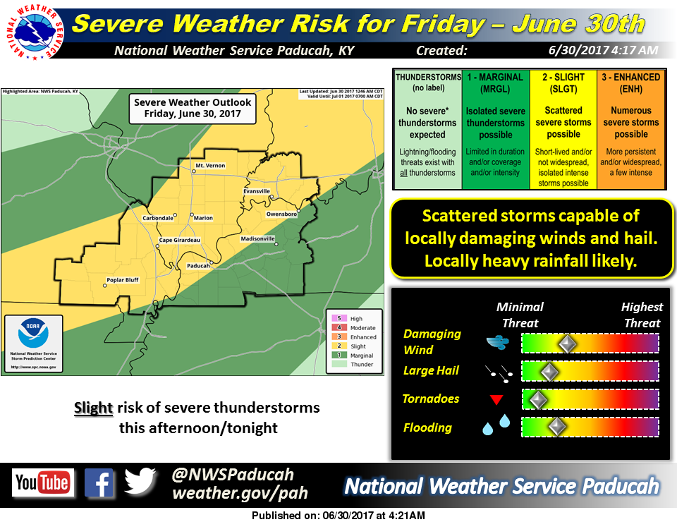
SPC upgrades to a slight risk of severe weatehr today

by Steve Dunford

The Storm Prediction Center upgraded all of Southern Illinois into a slight risk of severe weather.  There will be a slow moving cold front that will come through the region this evening.  There could be pop up storms in advance of the front.  As of now the main line of storms is projected to move through the region between 8-10 pm.

The zone of the slight risk of severe weather, cuts across the country from central Oklahoma all the way to Maine.

The biggest threat for the area is large damaging winds,  The hail and tornado threat is minimal, but can not be counted out.

I will keep you informed of and statements, watches and warnings.  During a severe weather threat it is impossible to keep up with the website, I will post most information on the Facebook page only.

Here is the hazardous weather outlook from the National Weather Service

.DAY ONE…Today and Tonight

There is a slight risk of severe thunderstorms along and northwest
of the Ohio River, including all of southeast Missouri. The
primary hazard will be locally damaging winds, but isolated large
hail and even a brief tornado cannot be ruled out. Southeast of
the slight risk area, isolated severe storms cannot be ruled out
southeast of the Ohio River. Heavy rainfall and frequent dangerous
lightning will accompany some storms. The primary time frame for
the strongest storms will be this afternoon and early tonight.

.DAYS TWO THROUGH SEVEN…Saturday through Thursday

More thunderstorms are possible Saturday as a cold front moves
across our region. The highest chance of storms is along and
southeast of a line from Cape Girardeau Missouri to Evansville
Indiana, where a few strong to severe storms are possible in the
afternoon.

There is a chance of thunderstorms again from Monday through
Thursday. There may be isolated strong storms, along with locally
heavy rainfall.

.SPOTTER INFORMATION STATEMENT…

Spotter activation may be requested, mainly this afternoon and
evening.

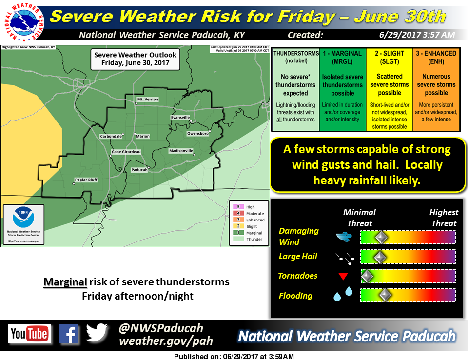
Marginal risk for severe weather for tomorrow and Saturday

by Steve Dunford

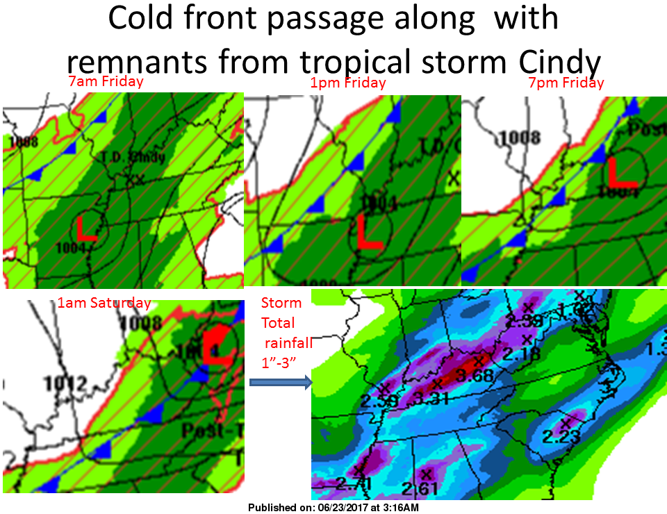
The unseasonably pleasant weather pattern will be turning into late June and early July type weather over the next several days.

I usually do not share when there is a marginal risk of severe weather (Level 1 of 5) until that day, but since we are approaching a holiday weekend I will share it in advance.  There is a marginal risk for Friday into Saturday for Southern Illinois.

What I am seeing in the charts is a risk of pop up thunderstorms on Friday afternoon for the region, and more widely scattered thunderstorms in the evening and overnight hours into Saturday morning.  The thunderstorm chances are slim (40% on Friday and 30% on Saturday) but it is something to keep an eye on if you are planning any outdoor activities.  As of now, it would not be a plan altering event.

Saturday night into Sunday looks dry, with rain chances coming back in on Monday and on the fourth.

Here is the Hazardous Weather Outlook form the National Weather Service in Paducah, KY .

DAY ONE…Today and Tonight A few thunderstorms are possible over parts of western Kentucky and southeast Missouri this afternoon, mainly along the Arkansas and Tennessee borders. Dangerous lightning will be the main hazard with any storms. .

DAYS TWO THROUGH SEVEN…Friday through Wednesday There is a chance of thunderstorms Friday through Saturday evening. An organized complex of thunderstorms is possible Friday afternoon into the night time hours. Locally damaging wind gusts and hail cannot be ruled out, along with heavy rainfall. There is a chance of thunderstorms Monday through Wednesday. There may be isolated strong storms, along with locally heavy rainfall.


Lashley Lifts Miners Over Rascals In Extras

The Southern Illinois Miners broke a 4-4 tie in the top of the 12th inning on a three-run home run by Ryan Lashley in a 7-5, extra-inning win over the River City Rascals at CarShield Field in O’Fallon, Missouri, taking the series two games to one in the rubber match between the division rivals.

It was the Rascals who scored first, as they bunched three singles together in the third inning off Chris Washington and went ahead 1-0 on Josh Silver’s hit. But in the top of the next inning, with a man on first, consecutive two-out hits by Anthony Critelli and Marc Flores set up Ben Moore, who drove home two with a single of his own with the bases loaded to give Southern Illinois its first lead at 2-1 in the fourth. In the fifth inning, the Rascals scored an unearned run on an RBI single by Braxton Martinez to knot the score at 2-2.

Southern Illinois would go ahead in the top of the sixth inning, as they loaded the bases on two walks and a single before Craig Massey broke the tie with a sacrifice fly to make it 3-2. With men at first and third base, Southern Illinois then executed a double-steal, with Moore swiping second and Flores stealing home to make it 4-2. But the Rascals would tie the score, as they chased Washington with two leadoff walks in the bottom of the sixth. After a sacrifice bunt moved the runners over to second and third, back-to-back RBI singles by Jason Merjano and Jimmy Kerrigan tied the game at 4-4. With the potential go-ahead run at third and just one out, however, Kyle Tinius induced Silver to ground into an inning-ending double play, keeping the score tied.

With the game turned over to the bullpens, both teams’s relief corps held the other team off the board, with Nick Palacios tossing two scoreless innings in the seventh and eighth and Chris DeBoo working out of trouble and stranding the bases loaded in the ninth. John Werner (2-0) pitched flawless frames in the tenth and eleventh along with four strikeouts, with neither team scoring with the International Tiebreaker in effect in the eleventh inning.

That changed in the twelfth, as Massey singled to move the automatic runner to third base leading off the inning. After a strikeout, Lashley came up and hammered the first pitch from Matt Chavarria (2-2) over the left field wall to make it 7-4. In the bottom half, Corey Sessions earned the save by permitting just one run to score, his first pro save in his first pro appearance as the Miners won the series.

Southern Illinois next moves on to Evansville to face another West Division rival in the Otters beginning on Friday night at 6:35 p.m. Tyler Stubblefield will take the hill for the Miners while Felix Baez will pitch the series opener for Evansville.

The Southern Illinois Miners are the 2016 Frontier League West Division Champions, the 2014 and 2015 Frontier League East Division Champions and the 2012 Frontier League Champions. They have been awarded the Frontier League Organization of the Year award three times since their inception, and also set a new Frontier League attendance record in 2007, their inaugural season. For ticket information, contact the Rent One Park box office at (618) 998-8499. For any additional information, visit our website at www.southernillinoisminers.com.

Box Score

Batting Stats

S Illinois
# Batter P AB R H RBI BB SO AVG
23 Massey, C SS 5 1 2 1 0 0 .304
6 Wiley, B 2B 6 0 2 0 0 2 .375
19 Lashley, R 3B 6 1 1 3 0 0 .246
25 Martin, W DH 6 1 1 0 0 0 .299
8 Wertz Jr., K CF 6 0 0 0 0 0 .231
15 Earley, N RF 5 0 0 0 0 2 .223
22 Critelli, A 1B 4 2 2 0 1 1 .500
27 Flores, M LF 3 1 1 0 2 1 .228
7 Moore, B C 5 1 3 2 0 0 .247
46 7 12 6 3 6

Batting
2B: B.Wiley (1).  HR: R.Lashley (6).  RBI: C.Massey (17), R.Lashley 3 (28), B.Moore 2 (8).  SF: C.Massey (3).  SB: M.Flores (9), B.Moore (3).
Team LOB: 9.

Fielding  A: C.Massey 3 (80), B.Wiley 3 (14), R.Lashley 2 (47), C.Washington (4), J.Werner (3).  DP: 1 (B. Wiley(2B) – C. Massey(SS) – A. Critelli(1B))  E: C.Massey (2), B.Wiley (3).  PO: C.Massey (66), B.Wiley 2 (15), R.Lashley (13), K.Wertz Jr. 4 (10), N.Earley 5 (57), A.Critelli 9 (9), M.Flores 3 (49), B.Moore 11 (200).  SBA: B.Moore 2 (42).  TC: C.Massey 5 (148), B.Wiley 6 (32), R.Lashley 3 (67), K.Wertz Jr. 4 (12), N.Earley 5 (60), A.Critelli 9 (10), M.Flores 3 (51), B.Moore 11 (213), C.Washington (5), J.Werner (4).

River City
# Batter P AB R H RBI BB SO AVG
2 Merjano, J 2B 6 0 1 1 0 3 .285
3 Kerrigan, J LF 6 1 2 1 0 2 .331
24 Silver, J 3B 6 0 4 1 0 1 .338
23 Martinez, B RF 4 0 1 1 0 0 .273
9   Love, T PH
RF
2 0 0 0 0 0 .225
10 Jurgella, M C 6 1 0 0 0 2 .263
33 Ludy, J DH 4 0 1 0 2 0 .269
18 Thomas, B CF 3 1 1 1 2 1 .202
8 Freeman, C 1B 5 2 2 0 1 1 .281
12 Morales, J SS 5 0 0 0 0 1 .194
47 5 12 5 5 11

Batting
RBI: J.Merjano (20), J.Kerrigan (25), J.Silver (21), B.Martinez (17), B.Thomas (12).  SF: B.Thomas (1).  SB: J.Silver (8), B.Thomas (16).
Team LOB: 15.

Fielding
A: J.Merjano 3 (99), J.Silver 5 (72), C.Freeman (14), J.Morales 5 (100), M.Chavarria (1), R.Smith 2 (2).  PO: J.Merjano (56), J.Kerrigan 3 (58), J.Silver (21), B.Martinez (105), M.Jurgella 6 (200), B.Thomas 6 (74), C.Freeman 16 (224), J.Morales (45), C.Mincey (1). SBA: M.Jurgella 2 (35).
TC: J.Merjano 4 (159), J.Kerrigan 3 (60), J.Silver 6 (99), B.Martinez (111), M.Jurgella 6 (223), B.Thomas 6 (75), C.Freeman 17 (242), J.Morales 6 (150), C.Mincey (2), M.Chavarria (2), R.Smith 2 (2).

Pitching Stats

S Illinois
# Pitcher IP H R ER BB SO ERA
16 Washington, C 5.0 8 4 3 2 3 2.57
40 Tinius, K 1.0 2 0 0 0 0 2.86
1 Palacios, N 2.0 0 0 0 2 3 5.14
12 DeBoo, C 1.0 1 0 0 1 1 3.18
28   Werner, J 2.0 0 0 0 0 4 2.89
18   Sessions, C 1.0 1 1 0 0 0 4.50
12 12 5 3 5 11

Pitching
BF: C.Washington 26, K.Tinius 4, N.Palacios 8, C.DeBoo 6, J.Werner 6, C.Sessions 4.
P-S: C.Washington 71-48, K.Tinius 10-6, N.Palacios 41-23, C.DeBoo 17-10, J.Werner 20-16, C.Sessions 15-10.

River City
# Pitcher IP H R ER BB SO ERA
31 Smith, R 4.2 8 2 2 0 0 3.86
22 Paesano, A 0.2 0 2 2 2 1 26.99
27 Zgardowski, J 2.2 1 0 0 0 4 2.46
6 Mincey, C 2.0 1 0 0 0 0 0.00
21 Laster, L 0.0 0 0 0 0 0 6.00
17 Kennedy, N 1.0 0 0 0 1 0 2.81
25 Losing Pitcher  Chavarria, M 1.0 2 3 2 0 1 3.45
12 12 7 6 3 6

Pitching
BF: R.Smith 22, A.Paesano 4, J.Zgardowski 9, C.Mincey 6, N.Kennedy 4, M.Chavarria 5.  P-S: R.Smith 64-43, A.Paesano 18-9, J.Zgardowski 33-22, C.Mincey 26-19, N.Kennedy 10-7, M.Chavarria 19-13.
WP: R.Smith (1).

  1 2 3 4 5 6 7 8 9 10 11 12 R H E
S Illinois 0 0 0 2 0 2 0 0 0 0 0 3 7 12 2
River City 0 0 1 0 1 2 0 0 0 0 0 1 5 12 0

Flood advisory issued for Franklin County

by Steve Dunford

The National Weather Service in Paducah has placed Franklin and surrounding counties in a Flood Advisory until 2:45 p.m.  There is a Flash Flood Watch issued until 10 p.m.

Jackson and Perry Counties are under a flash flood warning until

I have received reports from the Sesser area that State Route 148 has two inches of water over the road, one mile north of town.  The Sesser area has received four inches of rain overnight.  There are also reports of flooding on secondary roads in Northern Franklin and Southern Jefferson counties.

On the latest severe weather outlook from the Storm Prediction Center, there is no threat of severe weather.

Here is the flood advisory statement from the national weather service:

The National Weather Service in Paducah has issued a

* Flood Advisory for…
Union County in southern Illinois…
Southern Jefferson County in south central Illinois…
Johnson County in southern Illinois…
Williamson County in southern Illinois…
Eastern Jackson County in southern Illinois…
Franklin County in south central Illinois…
Southeastern Perry County in southeastern Missouri…
Northeastern Cape Girardeau County in southeastern Missouri…

* Until 245 PM CDT

* At 852 AM CDT, Doppler radar indicated heavy rain that will cause
minor flooding in the advisory area. Up to two to 3 inches, and
isolated higher amounts of rain have already fallen. Water has
been reported over a few roads in Franklin and Jefferson counties.

* Some locations that will experience flooding include…
Carbondale, Marion, Herrin, West Frankfort, Murphysboro, Benton,
Carterville, Anna, Johnston City, Christopher, Jonesboro, Vienna,
Rend Lake Area, Sesser, Zeigler, De Soto, Crainville, Cambria,
Cobden and Royalton.

PRECAUTIONARY/PREPAREDNESS ACTIONS…

Turn around, don`t drown when encountering flooded roads. Most flood
deaths occur in vehicles.
Excessive runoff from heavy rainfall will cause flooding of small
creeks and streams, country roads, farmland, and other low lying
spots.

Here is the Flash Flood Warning text for Jackson and Perry Counties

The National Weather Service in Paducah has issued a

* Flash Flood Warning for…
Perry County in south central Illinois…
Northwestern Jackson County in southern Illinois…
Northeastern Bollinger County in southeastern Missouri…
Perry County in southeastern Missouri…
Northwestern Cape Girardeau County in southeastern Missouri…

* Until 230 PM CDT Friday

* At 828 AM CDT, Doppler radar indicated heavy rain across the
warned area. Up to two to three inches of rain have already
fallen. Water has been reported over Highways T and 51 by Law
Enforcement. An additional 1 to 2 inches of rain is likely through
mid morning. Flash Flooding will become increasingly likely.

* Some locations that will experience flooding include…
Perryville, Murphysboro, Du Quoin, Pinckneyville, Elkville, Ava,
Tamaroa, Willisville, Grand Tower, Altenburg, Biehle, Alliance,
Daisy, Cutler, Dowell, Campbell Hill, Vergennes, Frohna, Oak Ridge
and Gorham.

PRECAUTIONARY/PREPAREDNESS ACTIONS…

Turn around, don`t drown when encountering flooded roads. Most flood
deaths occur in vehicles.
Here is the text for the Flash Flood Watch which the NWS extended until 10 p.m.

FLASH FLOOD WATCH IN EFFECT UNTIL 10 PM CDT THIS EVENING

The National Weather Service in Paducah has expanded the

* Flash Flood Watch to include portions of southern Illinois and
southeast Missouri, including the following areas, in southern
Illinois, Alexander, Edwards, Franklin, Gallatin, Hamilton,
Jefferson, Johnson, Pulaski, Saline, Union, Wabash, Wayne IL,
White, and Williamson. In southeast Missouri, Cape Girardeau
and Scott.

* Until 10  PM CDT this afternoon

* Widespread showers and isolated thunderstorms will continue to
produce locally heavy rainfall today. Tropical downpours have
been dumping up to 2 inches per hour in isolated locations in
southern Illinois.

* High rainfall rates could lead to rapid inundation of flood
prone roadways. Sharp rises in creeks and small streams may
occur. Low lying areas may quickly become flooded.


Flash Flood Warning for a small portion of Franklin County until 4:45

by Steve Dunford

The National Weather Service has issued a Flash Flood Warning until 4:45 for most of Southeastern Illinois, with the exception of Hardin and Massac Counties.

There is a small portion of Franklin County in the warned area, which would include Thompsonville and Akin.

I spoke with Franklin County Emergency Management agency, and the only road closure in the county is Satch Road in the Christopher/Buckner area.

I will continue to update periodically on road closures throughout the region.

Here is the warning text below

The National Weather Service in Paducah has issued a

* Flash Flood Warning for…
White County in southeastern Illinois…
Northern Pope County in southern Illinois…
Northern Johnson County in southern Illinois…
Eastern Williamson County in southern Illinois…
Saline County in southern Illinois…
Southeastern Franklin County in south central Illinois…
Hamilton County in south central Illinois…
Gallatin County in southern Illinois…

* Until 445 PM CDT Friday

* At 1040 AM CDT, Doppler radar indicated thunderstorms producing
heavy rain across the warned area. Up to three inches of rain have
already fallen in some locations. Flash flooding is expected to
begin shortly.

* Some locations that will experience flooding include…
Marion, Harrisburg, Carmi, Eldorado, McLeansboro, Shawneetown,
Grayville, Carrier Mills, Norris City, Goreville, Galatia, Ridgway,
New Harmony, Crossville, Enfield, Equality, Pittsburg, Creal
Springs, Lake Of Egypt Area and Carriers Mills.


Benton, West Frankfort, Illinois News | Franklin County News