| My soul thirsts for God, for the living God. When can I go and meet with God? |
| Psalm 42:2 (Read all of Psalm 42:2) New International |
FCN Daily Bible Verse
May 25, 2018 By Leave a Comment
John R. “Bob” Williams — Valier, IL
May 15, 2018 By Leave a Comment
John R. “Bob” Williams, 84, of Valier, IL, passed away on May 10, 2018.
He was born on March 21, 1934 in Macedonia, IL. He was a loving Dad, Grandpa and Great Grandpa. He was friendly and good natured. He always had a smile for everyone he met. He was funny and would do anything for anyone just to see them smile. He loved talking with people, he could talk for hours. He had so many great stories. He served the United States army in Germany for 21 months as a medic. He loved fishing, hunting, animals especially horses and dogs, camping, telling stories and spending time with his friends and family. He had numerous jobs in his life but the one he liked best was his Heating and Air Conditioning Business. He was preceded in death by his parents Oscar and Irene Williams, brother Eddie Williams and sister Sharon (Ron) Mabry. He is survived by his two children, Kevin Williams and Deb (Williams) Gabriel. Four grand-daughters, Christine (Lamone) Whitfield, Kaylee (Derek) Hillinger, Jordanna Marsh and Karissa Marsh. Two great-grandchildren Max Whitfield and Arya Scott. Several siblings: Charles (Janis) Williams, Carl (DeeAnn) Williams, Karen (Jim) Sanson, Brenda (Jim) Hewlett, Norma Bollinger, Linda (Ken) Aldridge and several nieces and nephews. He will be greatly missed by his friends and family. Funeral services will be at Valier First Baptist Church on Friday May 18 at 4:00 PM with visitation from 2:00 PM until the time of the service. There will be a luncheon at the church immediately following the ceremony. Memorial fund is being set up with National Coalition for Homeless Veterans (NCHV).
Loyola’s $8.5 million Final Four run boosts its rivals, too
April 2, 2018 By Leave a Comment
Loyola University Chicago’s unexpected march to college basketball’s Final Four will have financial reverberations well beyond its urban lakeside campus. Nine other schools stand to make money off its Cinderella run
March 21, 2018 By Leave a Comment

J.B Pritzker was the winner in Tuesday’s Democratic primary election defeating a crowded field of six candidates. He will face incumbent Gov. Bruce Rauner in the November general election. Rauner won a close and bitter contest against state Rep. Jeanne Ives.
Winter Weather Advisory for Franklin County until 4:00 a.m.
March 11, 2018 By Leave a Comment
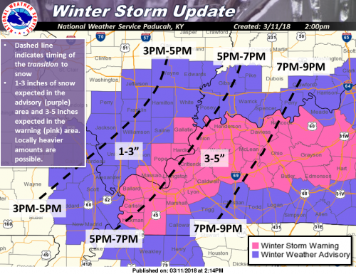
Here is the current Winter Storm Warning/Winter Weather Advisory for this afternoon and tonight. Expect 1-3 inches of snow in the advisory areas and 3-5 inches over the warning areas, with locally heavier amounts possible. Use extreme caution if driving as roads may become slick and visibility will be poor in heavier snow bands. (NWS Paducah)
WINTER WEATHER ADVISORY UNTIL 4 AM
.A burst of heavy wet snow expected late today and tonight...

.A low pressure system will form over the Tennessee Valley this
evening. Colder north winds will cause rain to change to snow. A
burst of heavy snow could produce a quick 1 to 3 inches, with
isolated higher totals possible.
.WINTER WEATHER ADVISORY IN EFFECT UNTIL 4 AM CDT MONDAY… * WHAT…Snow expected. Total snow accumulations of 1 to 3 inches are expected. Isolated higher amounts are possible in small bands of heavy snow. * WHERE...Portions of southwest Indiana, southeast Missouri and southern Illinois. * WHEN…Until 4 AM CDT Monday. * ADDITIONAL DETAILS…Plan on slippery road conditions. A burst of heavy snow could produce poor visibility below one-half mile. Although pavement temperatures will be above freezing, snowfall rates up to an inch per hour could produce a slushy accumulation on the roads, especially untreated, elevated roadways. PRECAUTIONARY/PREPAREDNESS ACTIONS... A Winter Weather Advisory for snow means periods of snow will cause primarily travel difficulties. Be prepared for snow covered roads and limited visibilities, and use caution while driving. The latest road conditions.
FRANKLIN COUNTY BREAKDOWN
In my opinion, the NWS included all the counties in the Paducah warning area in case there is a snow burst. Here is the forecast exclusive to every town in Franklin County updated by the National Weather Service.
- North of Route 14, the NWS has not issued an accumulation amount
- Zeigler, Royalton, and West Frankfort around an inch
- Thompsonville 1″ – 2″
- Keep in mind, there will be heavy snow bands, that could increase this amount
- Please be my eyes this afternoon and send accumulation amounts that way I can pass them along to the NWS.
WINTER STORM WARNING FOR GALLATIN, POPE HARDIN AND MASSAC COUNTIES
...A burst of heavy wet snow expected late today and tonight...

.A low pressure system will form over the Tennessee Valley this
evening. Colder north winds will cause rain to change to snow. A
burst of heavy snow could produce a quick 1 to 3 inches, with
isolated higher totals possible.
..WINTER STORM WARNING IN EFFECT UNTIL 4 AM CDT MONDAY...

* WHAT...Heavy wet snow expected. Total snow accumulations of 3 to
  5 inches are expected. Isolated higher amounts are possible in
  small bands of heavy snow.

* WHERE...Portions of western Kentucky and southern Illinois.

* WHEN...Until 4 AM CDT Monday.

* ADDITIONAL DETAILS...Plan on difficult travel conditions. Be
  prepared for significant reductions in visibility at times. Snow
  accumulations are expected, especially on grass, trees and
  untreated,elevated roadways. However, more hazardous travel
  conditions mat occur if the snow rates increase with
  temperatures near freezing.


PRECAUTIONARY/PREPAREDNESS ACTIONS...

A Winter Storm Warning for snow means severe winter weather
conditions will make travel very hazardous or impossible. If you
must travel, keep an extra flashlight, food and water in your
vehicle in case of an emergency. The latest road conditions for
the state you are calling from can be obtained by calling 5 1 1.
Slight chance of snow tonight – little or no accumulation expected
March 6, 2018 By Leave a Comment
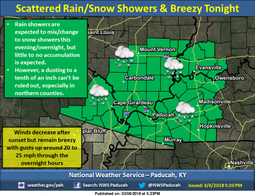
Rain showers early this evening will gradually mix with and change to snow showers for many locations as we progress through the evening and overnight hours. Breezy conditions will be present through the night as well. Temperatures are expected to fall through the 30s this evening and overnight, and be in the low to mid 30s by sunrise. (NWS Paducah)
SEVEN DAY FORECAST
Tonight
Scattered rain and snow showers before 11pm, then a slight chance of snow showers between 11pm and 5am, then a slight chance of flurries after 5am. Mostly cloudy, with a low around 33. West wind 13 to 16 mph, with gusts as high as 31 mph. Chance of precipitation is 30%.
Wednesday
Cloudy, then gradually becoming mostly sunny, with a high near 40. West northwest wind 11 to 14 mph, with gusts as high as 26 mph.
Wednesday Night
Partly cloudy, with a low around 26. West northwest wind 7 to 9 mph.
Thursday
Sunny, with a high near 41. West northwest wind 8 to 13 mph, with gusts as high as 21 mph.
Thursday Night
Partly cloudy, with a low around 27. West northwest wind around 6 mph becoming light and variable in the evening.
Friday
A slight chance of snow showers before 9am, then a slight chance of rain and snow showers between 9am and 10am, then a slight chance of rain showers after 10am. Mostly cloudy, with a high near 51. South southeast wind 3 to 7 mph. Chance of precipitation is 20%.
Friday Night
A chance of rain. Mostly cloudy, with a low around 37. East wind 5 to 7 mph.
Saturday
A chance of rain. Mostly cloudy, with a high near 54. East wind around 8 mph.
Saturday Night
A chance of rain. Mostly cloudy, with a low around 38. East wind 7 to 10 mph becoming north after midnight.
Sunday
A slight chance of rain. Mostly cloudy, with a high near 48. North northwest wind around 10 mph.
Sunday Night
Partly cloudy, with a low around 32. North northwest wind around 9 mph.
Monday
Mostly sunny, with a high near 48. North northwest wind 9 to 11 mph.
Monday Night
Mostly clear, with a low around 31. North wind 6 to 9 mph.
Tuesday
Sunny, with a high near 52. West northwest wind around 6 mph.
Wind advisory until 5:00 p.m. for Southern Illinois
March 6, 2018 By Leave a Comment
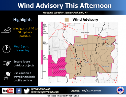
A Wind Advisory is in effect for most of the Heartland. Southwest to West Winds will increase to average speeds in the 15 to 30 mph range during the afternoon. Gusts may be as high as 40 to 50 mph at times. (NWS Paducah)
…WIND ADVISORY IN EFFECT FROM NOON TODAY TO 5 PM CST THIS AFTERNOON... The National Weather Service in Paducah has issued a Wind Advisory, which is in effect from noon today to 5 PM CST this afternoon.
* TIMING…This afternoon. * WINDS…Southwest winds 20 to 30 mph with gusts 40 to 50 mph.
* IMPACTS…Loose outdoor objects not secured may be blown around. Some tree limbs could come down. Driving high profile vehicles will be more difficult.
PRECAUTIONARY/PREPAREDNESS ACTIONS… A wind advisory is issued when sustained winds are expected to reach 30 mph or greater for longer than one hour…or wind gusts are expected to reach 40 mph for any duration.
This Hazardous Weather Outlook is for portions of southern Illinois, southwest Indiana, western Kentucky, and southeast Missouri. .
DAY ONE…Today and Tonight A Red Flag Warning is in effect this afternoon for the southeast Missouri Ozarks. Refer to the Warning for details. A Wind Advisory is in effect this afternoon for most of the area. Refer to the Advisory for details. Flood warnings will continue. Reference the warnings and statements for details. .
DAYS TWO THROUGH SEVEN…Wednesday through Monday Flood warnings will continue. Reference the warnings and statements for details. A small chance of thunderstorms is possible Saturday night, for southern sections of western Kentucky and southeast Missouri. Severe storms are not expected.
.SPOTTER INFORMATION STATEMENT… Spotter activation will not be needed.
SEVEN DAY FORECAST
This Afternoon
Sunny early, then becoming mostly cloudy, with a temperature falling to around 47 by 5pm. Breezy, with a west wind 15 to 20 mph, with gusts as high as 38 mph.
Tonight
Scattered rain showers before 10pm, then scattered rain and snow showers between 10pm and midnight, then scattered snow showers after midnight. Mostly cloudy, with a low around 33. West wind 11 to 15 mph, with gusts as high as 31 mph. Chance of precipitation is 30%.
Wednesday
Cloudy, then gradually becoming mostly sunny, with a high near 40. West northwest wind 11 to 14 mph, with gusts as high as 26 mph.
Wednesday Night
Partly cloudy, with a low around 27. West northwest wind 6 to 10 mph.
Thursday
Sunny, with a high near 41. West northwest wind 7 to 11 mph.
Thursday Night
Partly cloudy, with a low around 28. West northwest wind around 6 mph becoming light and variable in the evening.
Friday
A slight chance of snow before 9am, then a chance of rain. Mostly cloudy, with a high near 51. South wind 3 to 8 mph. Chance of precipitation is 30%.
Friday Night
Rain likely, mainly before midnight. Mostly cloudy, with a low around 40. South southeast wind around 7 mph becoming northwest after midnight.
Saturday
A slight chance of rain after noon. Mostly cloudy, with a high near 55. North wind around 7 mph.
Saturday Night
A chance of rain. Mostly cloudy, with a low around 38. North wind 7 to 9 mph.
Sunday
A chance of rain. Partly sunny, with a high near 47. North northwest wind 10 to 15 mph, with gusts as high as 24 mph.
Sunday Night
Partly cloudy, with a low around 31. North northwest wind 8 to 11 mph.
Monday
Sunny, with a high near 49. North northwest wind 8 to 10 mph.
Police respond after possible self-inflicted shot near White House, Secret Service says
March 3, 2018 By Leave a Comment
The following are tweets from the US secret Service

Independent UK photo.
WASHINGTON, DC – Secret Service personnel are responding to reports of a person who allegedly suffered a self-inflicted gun shot wound along the north fence line of @WhiteHouse.
UPDATE: No other reported injuries related to the incident at @WhiteHouse.
John Roberts of Fox News says the following: “Medical personnel are responding to the incident. The person involved in the incident was not immediately identified and his condition was unknown.”
A White House official told Fox News that President Trump has been briefed on the incident and referred all questions to the Secret Service.
President Trump is currently in Mar-a-Lago and is expected to return to Washington, D.C., later on Saturday.
Please follow the link for this breaking story from Fox News.
Southbound I-57 closed at Ina Exit for rollover crash
March 2, 2018 By Leave a Comment
WHITTINGTON – Sesser and Benton Fire, Illinois State Police, Abbott EMS, and Air Evac are on the scene of a single vehicle with a camper rollover crash, on I 57 at the 80 mile marker, just south of the Franklin-Jefferson county line.
Please take an alternate route. It has been cofirmed from the Jefferson County Sheriff’s office the interstate will be closed until the accident scene is cleared.
Further updates will be provided as the come available. -sd
4:45 P.M. Incident has been cleared. Traffic is flowing normally.
Franklin County Sheriff’s office non emergency lines down
February 27, 2018 By Leave a Comment
 From Franklin County Emergency Management Agency
BENTON – Franklin County Sheriff’s Office Dispatch Center is experiencing a phone outage on their non-emergency lines. Until further notice, please use 618-435-2250 for non-emergency calls to the Sheriff’s Office.
DO NOT CALL 911 UNLESS IT IS AN EMERGENCY!!!!!!!!
UPDATE 9:30 a.m. I just was in contact with Franklin County EMA, and the lines are still down according to their last report.
