Flood Warning for all of Southern Illinois until 9:00 a.m. Sunday

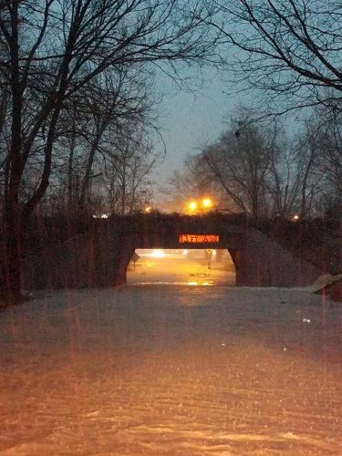
The railroad underpass on Route 14 in McLeamsboro earlier this evening. (Hamilton County EMA photo)

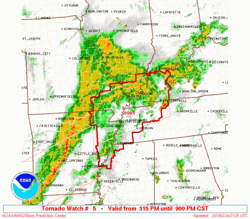
The National Weather Service in Paducah has issued a Flood Warning for… Perry County in south central Illinois… Union County in southern Illinois… Wayne County in south central Illinois… Northern Pope County in southern Illinois… Jefferson County in south central Illinois… Johnson County in southern Illinois… Williamson County in southern Illinois… Saline County in southern Illinois… Jackson County in southern Illinois… Northwestern Alexander County in southern Illinois… Franklin County in south central Illinois... Hamilton County in south central Illinois…

* Until 900 AM CST Sunday * Although rain has ended across most of southern Illinois, some creeks and streams will remain out of their banks at least through tonight. Low-lying flood-prone areas will remain inundated. Flood- prone roads will likely remain covered with water through at least early Sunday.

PRECAUTIONARY/PREPAREDNESS ACTIONS… Turn around, don`t drown when encountering flooded roads. Most flood deaths occur in vehicles. Be especially cautious at night when it is harder to recognize the dangers of flooding.


Franklin County EMA reports the following roads are flooded

Use caution when traveling. Flash flooding has been reported on the following roadways:

West Frankfort:

Main to Horrell 
Monroe 1000 blk
Logan to Locust – E St. Louis
Highway 149 washout in front of Casey’s East-
500 Blk E Elm

Franklin County:

#9 Blktop to Taylor rd bridge overflow
State Highway 34 / Pickle City
Akin Blktp / 34
Deering / Gossett
Akin Blktp/ Buntin
Pershing Rd between Tate and Burbank
Deering/Rumbler Crossing


SEVERAL other local roadways are experiencing flash flooding. This list is not all inclusive. Never drive through a flooded roadway. TURN AROUND, DONT DROWN!

Wreck on I 57 between Benton and Sesser exit

WHITTINGTON –  Sesser and Benton firefighters are responding to semis wrecked in the median on I-57 at the 75 mile marker.  This could involve slowdowns in traffic both directions.

If you do not have to travel, don’t.  I know some travel is necessary to work etc.  -sd

Flooding update

First of all this will be updated frequently.

  • There are several reports of flash flooding on Route 149 between West Frankfort and Thompsonville.
  • Several streets in Carterville, Herrin and Marion are flooded.
  • West Frankfort street commissioner Tara Chambers reports there are several places in town that are flooded and crews are trying to barricade them as quick as possible. 6:05 p.m.
  • Johnston City PD reports several streets are flooded. 6:05.
  • Water is over the road in 3 places on the Akin Blacktop, between the 4 way stop and Jackson Grove Church. The Akin 4 way has water over it. North Thompsonville Road has water over it in two or three places, from Akin to Thompsonville. Carlyle Road has water over it in 3 or 4 places, at least. Perryman Road has water over it in several places.  This is Northeast of Thompsonville.
  • From the West Frankfort Fire Department. There is widespread flooding in WF and the surrounding area. If you dont have to get out please stay home.
  • As flooding continues we ask at this time do not travel unless absolutely necessary. Please obey any road blocks that have been posted. Find alternate routes and do not drive through standing water. Please share and be safe.  From Benton FD
  • The Six Mile Township supervior reports the ditches full on Creek Nation Road, but not over the road.

Flash Flood Warning until 9:00 p.m. for Franklin and surrounding counties

The National Weather Service in Paducah has issued a * Flash Flood Warning for… Perry County in south central Illinois… Union County in southern Illinois… Pulaski County in southern Illinois… Johnson County in southern Illinois… Williamson County in southern Illinois… Jackson County in southern Illinois… Alexander County in southern Illinois… Franklin County in south central Illinois… Scott County in southeastern Missouri… Perry County in southeastern Missouri… Cape Girardeau County in southeastern Missouri… * Until 900 PM CST *

At 354 PM CST, Doppler radar indicated thunderstorms with heavy rain were moving into the warned area. Close to 5 inches of rain have fallen over the past four days or so. Rainfall rates around one-half inch per hour are developing over the region. Flash flooding is expected to begin shortly. * Some locations that will experience flooding include… Cape Girardeau, Carbondale, Marion, Sikeston, and Herrin. Additional rainfall amounts of 1 to 3 inches are likely in the warned area through early this evening. Rapid rises in water levels will occur. This is a potentially life-threatening situation.

PRECAUTIONARY/PREPAREDNESS ACTIONS… Turn around, don`t drown when encountering flooded roads. Most flood deaths occur in vehicles.

Tornado Watch until 9:00 p.m. for the counties just to our south and east

The NWS Storm Prediction Center has issued a * Tornado Watch for portions of Eastern Arkansas Southern Illinois Western Kentucky Southeast Missouri Northwest Mississippi West Tennessee * Effective this Saturday afternoon and evening from 315 PM until 900 PM CST.

COUNTIES IN SOUTHERN ILLINOIS:  Saline, Gallatin, Union, Johnson, Pope, Hardin, Alexander, Pulaski, and Massac

* Primary threats include… A few tornadoes likely with a couple intense tornadoes possible Widespread damaging winds likely with isolated significant gusts to 75 mph possible Isolated large hail events to 1.5 inches in diameter possible

SUMMARY…A line of intense thunderstorms over central AR will track rapidly eastward across the watch area this afternoon and evening. Damaging winds and a few tornadoes are the main threats. The tornado watch area is approximately along and 70 statute miles north and south of a line from 10 miles west southwest of Walnut Ridge AR to 30 miles northeast of Fort Campbell KY. For a complete depiction of the watch see the associated watch outline update (WOUS64 KWNS WOU5).

Chance of heavy rain and severe thunderstorms today


Tom Dart


Former Ald. Daniel Solis leaves Dirksen U.S. Courthouse after testifying in the corruption trial of former Speaker Michael Madigan.
Happy New Year! Blessings to you and your family in 2025!

We’re continuing to monitor the potential for severe thunderstorms later this afternoon and evening. The primary concerns include damaging winds and flooding rains, with a smaller risk for a few tornadoes. Do you have a way to receive warning alerts and a plan of action to seek shelter in case severe weather threatens today? (NWS Paducah)

As long as the temperature remains in the low 50’s the chance of severe weather, especially tornadoes for this region lessens.   The further south you go, or if you are south of the cold front, the tornado chance increases.

If the sun comes out and it warms up quickly into the 60’s is when we will be under the gun.

We will still be monitoring the situation.  Follow the website’s Facebook page for info on the upcoming weather from area meteorologists.

Below are the statements issued by the National Weather Service.

Flood Warning for the Big Muddy

The National Weather Service in Paducah, Kentucky has issued a * Flood Warning for the Big Muddy River near Plumfield. * from late Sunday night to late Wednesday night.

* At 10:00 AM Saturday the stage was 17.9 feet. * Flood Stage is 20.0 feet. * Minor flooding is forecast.

* Forecast…Rise above flood stage by Monday morning and continue to rise to near 21.1 feet by Tuesday morning. * Impact…At 20.0 Feet…Minor flooding occurs affecting mainly bottom land and surrounding low lying area.

Flood Watch Until 6:00 a.m. Sunday

…FLOOD WATCH REMAINS IN EFFECT THROUGH LATE TONIGHT… The Flood Watch continues for * All of southeast Missouri, southern Illinois, southwest Indiana and western Kentucky. * Through late tonight.

* Showers and thunderstorms will be on the increase today, peaking in coverage and intensity later this afternoon and evening as a cold front approaches. With ground conditions already saturated, any additional rain from thunderstorms will only worsen existing areal flooding. Additionally, heavier rainfall rates from strong thunderstorms could easily produce dangerous flash flooding.

* Additional rains will aggravate already ongoing flooding of area rivers and tributaries across the region. Smaller streams and creeks not currently in flood will fill up and overspill their banks quickly, heightening the flood threat. In addition, elevated water levels in low lying and poor drainage areas, as well as waters that may not yet have receded from antecedent rainfall, may lead to more road closures due to high water crossings.

PRECAUTIONARY/PREPAREDNESS ACTIONS… A Flood Watch means there is a potential for flooding based on current forecasts. You should monitor later forecasts and be alert for possible Flood Warnings. Those living in areas prone to flooding should be prepared to take action should flooding develop. Heed all flood warning signs, and never cross a flooded roadway. Turn around and don`t drown! Remember it is harder to see rising waters at night. Seek high ground immediately if you encounter an area with rising waters.

Hazardous Weather Outlook 

This Hazardous Weather Outlook is for portions of southern Illinois, southwest Indiana, western Kentucky, and southeast Missouri. .

DAY ONE…Today and Tonight There is a risk of severe thunderstorms this afternoon and evening. Damaging winds will be the main hazard. There is a risk of a few tornadoes as well. The areas with the highest probability for a tornado or two are southeast of a Cape Girardeau, Poplar Bluff Missouri line into far west Kentucky, mainly west of the Lakes, and the southern tip of Illinois.

Additional rainfall of up to 2 inches, with isolated higher amounts possible, will result in an additional flooding risk across the region today into tonight, especially across southeast Missouri into west Kentucky. A Flood Watch remains in effect through tonight for the entire region.

With stronger thunderstorm activity, Flash Flooding will be possible. Updates and details on continued river flooding can be referenced on the latest flood warnings and statements. .

DAYS TWO THROUGH SEVEN…Sunday through Friday Updates and details on continued river flooding can be referenced on the latest flood warnings and statements.

.SPOTTER INFORMATION STATEMENT… Spotter activation will be likely this afternoon and evening. Additional heavy rainfall and flooding reports are requested.

Seven Day Forecast 

This Afternoon
A chance of showers and thunderstorms, then showers and possibly a thunderstorm after 3pm. Some of the storms could produce heavy rain. High near 62. East southeast wind around 7 mph. Chance of precipitation is 100%.
Tonight
Showers and thunderstorms before midnight, then a slight chance of showers between midnight and 1am. Some storms could be severe, with heavy rain. Low around 40. South wind 8 to 18 mph becoming west after midnight. Winds could gust as high as 30 mph. Chance of precipitation is 100%.
Sunday
Sunny, with a high near 54. West wind 5 to 9 mph becoming south southwest in the afternoon.
Sunday Night
Mostly clear, with a low around 35. Light south southeast wind.
Monday
Sunny, with a high near 61. Calm wind becoming south around 5 mph.
Monday Night
Clear, with a low around 37. Light south southeast wind.
Tuesday
Mostly sunny, with a high near 64. Light south southeast wind becoming south 6 to 11 mph in the morning.
Tuesday Night
Showers likely after midnight. Mostly cloudy, with a low around 49. South wind 6 to 8 mph.
Wednesday
A chance of showers. Cloudy, with a high near 64. South wind around 8 mph.
Wednesday Night
Showers likely. Mostly cloudy, with a low around 49. South southwest wind 8 to 14 mph, with gusts as high as 20 mph.
Thursday
A chance of showers. Partly sunny, with a high near 59. Breezy, with a southwest wind 15 to 21 mph, with gusts as high as 29 mph.
Thursday Night
Partly cloudy, with a low around 36. West northwest wind 13 to 17 mph, with gusts as high as 23 mph.
Friday
Mostly sunny, with a high near 53. Northwest wind 9 to 11 mph.

Marginal risk of severe weather for tomorrow

We’re continuing to monitor the potential for severe thunderstorms late Saturday afternoon and evening. The primary concerns include damaging winds and flooding rains, with a smaller risk for a few tornadoes. Do you have a way to receive warning alerts and a plan of action to seek shelter in case severe weather threatens this weekend? (NWS Paducah)

Hazardous Weather Outlook

A band of showers and a few thunderstorms will continue to produce moderate to heavy rainfall through at least midday as they stream over far southeast Missouri, much of west Kentucky and the southern tip of Illinois.

After a brief dry period this afternoon, more showers and thunderstorms will develop and lift northeast across the region tonight. Heavy rainfall and worsening flood problems can be expected. Please refer to the Flood Watch for details. Minor to moderate flooding continues or is imminent for the Ohio and Green Rivers, as well as parts of the Mississippi, Big Muddy, Patoka, and Wabash Rivers.

Please see the latest river flood warnings and statements for further details. .

DAYS TWO THROUGH SEVEN…Saturday through Thursday Widespread showers and thunderstorms with moderate to heavy rainfall are expected Saturday and Saturday night.

The Flood Watch continues until 6 AM Sunday. Please refer to the watch for details. The potential for severe thunderstorms with widespread damaging winds and a tornado threat exists late Saturday afternoon through the evening hours. The storms will most likely be in a line on or near a cold front that will move eastward across the region.

Minor to moderate flooding continues or is imminent for the Ohio and Green Rivers, as well as part of the Mississippi, Big Muddy, Patoka, and Wabash Rivers. Please see the latest river flood warnings and statements for further details. .

SPOTTER INFORMATION STATEMENT… Spotter activation is becoming more likely Saturday afternoon and evening. In addition, reports of heavy rainfall and flooding would be very helpful today through Saturday night.

…FLOOD WATCH REMAINS IN EFFECT THROUGH LATE SATURDAY NIGHT…

The Flood Watch continues for * All of southern Illinois, southwest Indiana, western Kentucky, and southeast Missouri. * Through late Saturday night.

* Periods of showers and thunderstorms will produce another 2 to 4 inches of rainfall through Saturday night. Isolated higher amounts will be possible. With saturated soil, the result will be worsening areal flood problems and the potential for flash flooding, especially Saturday afternoon and evening.

* The main flooding concern initially will be along small streams and creeks that feed into already swollen rivers across the region. Elsewhere, elevated water levels in low lying and poor drainage areas may lead to standing water across some roads that typically flood. However, a line of strong to severe thunderstorms Saturday afternoon and evening may result in more significant flash flooding over much of the region.

PRECAUTIONARY/PREPAREDNESS ACTIONS… A Flood Watch means there is a potential for flooding based on current forecasts. You should monitor later forecasts and be alert for possible Flood Warnings. Those living in areas prone to flooding should be prepared to take action should flooding develop.

Seven Day Forecast

Today
A 30 percent chance of showers, mainly after 5pm. Cloudy, with a high near 55. West wind 5 to 9 mph becoming calm in the afternoon. Winds could gust as high as 20 mph.
Tonight
Showers, with thunderstorms also possible after 3am. Some of the storms could produce heavy rain. Low around 48. Calm wind becoming east northeast 5 to 8 mph in the evening. Chance of precipitation is 90%.
Saturday
Showers and possibly a thunderstorm. Some storms could be severe, with damaging winds and heavy rain. High near 64. East northeast wind 7 to 10 mph becoming south in the morning. Chance of precipitation is 100%.
Saturday Night
Showers and possibly a thunderstorm before midnight, then a slight chance of showers. Some storms could be severe, with damaging winds and heavy rain. Low around 41. South wind 11 to 15 mph becoming west after midnight. Winds could gust as high as 29 mph. Chance of precipitation is 90%.
Sunday
Sunny, with a high near 55. West wind 5 to 10 mph.
Sunday Night
Mostly clear, with a low around 35. Light and variable wind.
Monday
Sunny, with a high near 58. Light and variable wind.
Monday Night
Clear, with a low around 38. South southeast wind 3 to 5 mph.
Tuesday
Mostly sunny, with a high near 63. Light south southeast wind becoming south 5 to 10 mph in the morning.
Tuesday Night
Showers after midnight. Mostly cloudy, with a low around 48. South wind around 8 mph.
Wednesday
A chance of showers. Mostly cloudy, with a high near 61. South wind 6 to 8 mph.
Wednesday Night
A chance of showers. Mostly cloudy, with a low around 45. Southeast wind 8 to 10 mph becoming west southwest after midnight.
Thursday
A chance of showers. Partly sunny, with a high near 56. West wind 10 to 15 mph, with gusts as high as 24 mph.


Summer Employment Available at Rend Lake

BENTON –  The U.S. Army Corps of Engineers at Rend Lake is looking for qualified candidates to fill student vacancies for the 2018 summer recreation season. Rend Lake offers a great work experience opportunity for students pursuing a career in the field of biology, outdoor recreation, or law enforcement.

Student Trainee positions are available at the GS-02 level for graduating high school seniors and college students. Job openings are available for positions in the areas of Interpretive Services, Visitor Assistance, Facilities/Grounds Maintenance, and Environmental Stewardship at an hourly rate of approximately $11.68. During the summer term employees will work a 40-hour schedule. Candidates may be required to work a combination of days, nights, weekends, and holiday shifts.

The vacancy is available online at www.usajobs.gov under the job announcement number. Applicants must create a USAJOBS account, build a profile, and create a resume. The job announcement can be located by entering the announcement number into the “keyword” search query on the homepage. Applicants are strongly encouraged to call the Rend Lake Project Office at (618) 724-2493 for any questions or assistance in applying for these positions. This announcement closes on March 8th and complete application packages must be received on or before this date to be considered. The announcement number is SWGI186073391554PI .

Basic Requirements and Qualifications are:

• Must be enrolled or accepted for enrollment in a technical or vocational school, 2-year or 4-year college or university, graduate or professional school, at a qualifying educational institution on a half-time or full-time basis pursuing a qualifying degree or certificate.
• Minimum education requirement of high school diploma or GED.
• Good academic standing with a cumulative 2.0 grade point average.
• Transcripts and proof of enrollment/acceptance letter.
• Detailed resume showing eligibility for this position.
• Required to sign a Pathways Participant Agreement.
• Must be at least 18 years old

Direct link to the announcement: https://www.usajobs.gov/GetJob/ViewDetails/491509100

..WINTER WEATHER ADVISORY IN EFFECT UNTIL NOON CST TODAY…

A large area of precipitation will continue through the morning hours for the Quad State Region. Mainly rain is expected over west Kentucky, with a rain/snow mix expected across the rest of the region. Some snow accumulations are expected, mainly on grassy surfaces. (NWS Paducah)


…WINTER WEATHER ADVISORY IN EFFECT UNTIL NOON CST TODAY…for the following counties in Southern Illinois.  Jefferson-Wayne IL-Edwards-Wabash-Perry IL-Franklin-Hamilton- White-Jackson-Williamson-Saline-Gallatin-Union-Johnson

* WHAT…Snow. Accumulations of up to two inches are expected. * WHERE…Portions of southeast Missouri and southern Illinois.

* WHEN…Until noon CST today.

* ADDITIONAL DETAILS…Plan on slippery road conditions. Be prepared for reduced visibilities at times.

Benton, West Frankfort, Illinois News | Franklin County News