Wet snow switching to rain today…..a sunny Sunday…then very wet

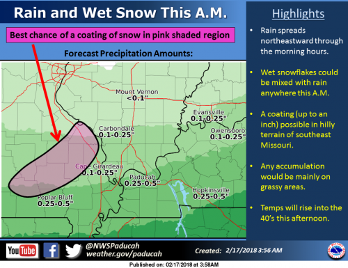
As rain spreads northeast across the region, some wet snow could be mixed in this morning. There is even a chance of some minor snow accumulations in the hilly terrain of southeast Missouri, mainly north and west of Cape Girardeau. Up to an inch of slushy accumulation is possible on grassy areas. Any snow will melt this afternoon as temperatures climb into the 40’s.

Hydrologic Outlook


…Excessive rainfall is likely across the region during the upcoming week…

Multiple weather systems will produce a combined several inches of rainfall from Sunday night through the middle of next week.

Another round of rainfall is possible next Friday into next weekend. The areas that should receive the heaviest rainfall include southeast Missouri, southern Illinois and possibly southwest Indiana. Slightly lower totals are forecast across west Kentucky.

The excessive rainfall may impact our major rivers and their tributaries. If you live in river bottom lands, keep up to date on the latest forecasts. Low lying, poor drainage areas may experience flooding as well.

Hazardous Weather Outlook


This Hazardous Weather Outlook is for portions of southern Illinois, southwest Indiana, western Kentucky, and southeast Missouri. .

DAY ONE…Today and Tonight

Rain and some wet snow will occur this morning. Some wet snowflakes could be mixed with the rain anywhere across the region early this morning. The best chance of any minor snow accumulations will be across portions of southern Illinois and southeast Missouri, mainly north and west of a Cape Girardeau to Carbondale line. Any accumulations will be mainly on grassy areas, possibly up to an inch. Temperatures will rise into the lower 40s this afternoon, melting any snow that does accumulate.

.DAYS TWO THROUGH SEVEN.

..Sunday through Friday A prolonged period of wet weather over the Ohio and Mississippi River valleys next week could result in the potential for some flooding. The potential will become more clear as we gain a better idea of where and exactly how much rainfall may occur. Flooding is forecast to continue along the Green and Ohio rivers. Refer to those warnings and statements for details. .

SPOTTER INFORMATION STATEMENT… Spotter activation will not be needed.

Seven Day Forecast

Saturday
Rain and snow likely, becoming all rain after 10am. Cloudy, with a high near 42. Southeast wind 5 to 10 mph becoming west southwest in the afternoon. Chance of precipitation is 70%. New snow accumulation of less than a half inch possible.
Saturday Night
Patchy fog after 1am. Otherwise, partly cloudy, with a low around 30. Southwest wind 5 to 8 mph becoming calm in the evening.
Sunday
Mostly sunny, with a high near 55. Light southeast wind becoming south 8 to 13 mph in the morning. Winds could gust as high as 18 mph.
Sunday Night
Showers, mainly after midnight. Low around 49. South wind 10 to 15 mph, with gusts as high as 26 mph. Chance of precipitation is 80%.
Washington’s Birthday
Showers likely, mainly before noon. Cloudy, with a high near 68. Breezy, with a south southwest wind 16 to 20 mph, with gusts as high as 33 mph. Chance of precipitation is 70%.
Monday Night
A chance of showers and thunderstorms, then showers likely and possibly a thunderstorm after midnight. Cloudy, with a low around 61. South wind around 16 mph, with gusts as high as 28 mph. Chance of precipitation is 60%.
Tuesday
Showers and possibly a thunderstorm. Cloudy, with a high near 70. Breezy, with a south southwest wind 16 to 20 mph, with gusts as high as 31 mph.
Tuesday Night
Showers. Cloudy, with a low around 41. West southwest wind 13 to 16 mph becoming north northwest after midnight. Winds could gust as high as 25 mph.
Wednesday
Showers likely, mainly after noon. Mostly cloudy, with a high near 44. North northwest wind 10 to 16 mph, with gusts as high as 25 mph.
Wednesday Night
A chance of rain and snow. Mostly cloudy, with a low around 32. North wind 8 to 11 mph, with gusts as high as 18 mph.
Thursday
Mostly cloudy, with a high near 48. East northeast wind around 8 mph.
Thursday Night
A chance of showers. Mostly cloudy, with a low around 39. East northeast wind around 7 mph becoming southeast after midnight.
Friday
Showers likely. Cloudy, with a high near 58. Southeast wind 7 to 9 mph becoming south southwest in the afternoon.

Former Zeigler Treasurer Ryan Thorpe to plead guilty to Federal charges

The FBI raiding Ziegler City Treasurer Ryan Thorpe’s home in August. Photo Taken by William McPerson of the West Frankfort Gazette.

BENTON – WSIL-TV reports that former Zeigler City treasurer Ryan Thorpe will entertain a guilty plea tomorrow in Federal Court in Benton.

Thorpe is being charged with three counts of wire fraud and two counts of embezzlement after stealing $315,000 from the city.

The court date is set for March 1st.

Here is the story from WSIL-TV this evening.

http://www.wsiltv.com/story/37510019/former-zeigler-treasurer-to-plea-guilty-to-federal-charges

Ameren announces planned power outage in West City

WEST CITY –Ameren will conduct a planned power outage Tuesday, February 13, from 11:00 pm until 5:00 am in the Village of West City.

This is for only 131 customers in West City. Ameren has replaced an 80 foot pole and needs to move the service over to the new pole. If all goes well, the outage should only be within the specified time range

Moweaqua (Central A & M) Class 1A Boys Basketball Sectional pairings

Moweaqua (Central A & M) Sectional

Tue., Feb. 27

Game 1 at 7:00 pm: Winner Nokomis Regional vs. Winner Hutsonville Regional

Wed., Feb. 28

Game 2 at 7:00 pm: Winner Patoka Regional vs. Winner Windsor Regional

Fri., Mar. 2

Game 3 at 7:00 pm: Winner Game 1 vs. Winner Game 2

Windsor Regional

Mon., Feb. 19

Game 1 at 7:00 pm: (6) Windsor [Coop] vs. (7) Arcola

Tue., Feb. 20

Game 2 at 6:00 pm: (3) Mulberry Grove vs. (9) Chrisman

Game 3 at 7:30 pm: (5) Bethany (Okaw Valley) vs. (8) Hume (Shiloh) [Coop]

Wed., Feb. 21

Game 4 at 6:00 pm: (2) Moweaqua (Central A & M) vs. Winner Game 1

Game 5 at 7:30 pm: Winner Game 2 vs. Winner Game 3

Fri., Feb. 23

Game 6 at 7:00 pm: Winner Game 4 vs. Winner Game 5

Patoka Regional

Mon., Feb. 19

Game 1 at 7:00 pm: (6) Centralia (Christ Our Rock Lutheran) vs. (8) Louisville (North Clay) [Coop]

Tue., Feb. 20

Game 2 at 6:00 pm: (4) Odin vs. (13) Sandoval

Game 3 at 7:30 pm: (5) Farina (South Central) vs. (12) Patoka

Wed., Feb. 21

Game 4 at 6:00 pm: (1) Dieterich vs. Winner Game 1

Game 5 at 7:30 pm: Winner Game 2 vs. Winner Game 3

Fri., Feb. 23

Game 6 at 7:00 pm: Winner Game 4 vs. Winner Game 5

Nokomis Regional

Mon., Feb. 19

Game 1 at 7:00 pm: (11) Edinburg [Coop] vs. (12) Ramsey

Tue., Feb. 20

Game 2 at 6:00 pm: (4) Neoga vs. (14) Niantic (Sangamon Valley)

Game 3 at 7:30 pm: (10) Buffalo (Tri-City) vs. (13) Beecher City [Coop]

Wed., Feb. 21

Game 4 at 6:00 pm: (1) Nokomis vs. Winner Game 1

Game 5 at 7:30 pm: Winner Game 2 vs. Winner Game 3

Fri., Feb. 23

Game 6 at 7:00 pm: Winner Game 4 vs. Winner Game 5

Hutsonville Regional

Mon., Feb. 19

Game 1 at 6:00 pm: (9) Oblong vs. (10) Cisne

Game 2 at 7:30 pm: (7) Hutsonville [Coop] vs. (11) Martinsville

Tue., Feb. 20

Game 3 at 7:00 pm: (2) Altamont vs. Winner Game 1

Wed., Feb. 21

Game 4 at 7:00 pm: (3) St. Elmo [Coop] vs. Winner Game 2

Fri., Feb. 23

Game 5 at 7:00 pm: Winner Game 3 vs. Winner Game 4


Class 2A Boys Basketball Robinson Sectional parings

Robinson Sectional

Tue., Feb. 27

Game 1 at 7:00 pm: Winner Vandalia Regional vs. Winner Lawrenceville Regional

Wed., Feb. 28

Game 2 at 7:00 pm: Winner Fairfield Regional vs. Winner Casey (C.-Westfield) Regional

Fri., Mar. 2

Game 3 at 7:00 pm: Winner Game 1 vs. Winner Game 2

Farifield Regional

Mon., Feb. 19

Game 1 at 6:00 pm: (7) Fairfield vs. (8) McLeansboro (Hamilton County)

Game 2 at 7:30 pm: (6) Flora vs. (10) Albion (Edwards County)

Tue., Feb. 20

Game 3 at 7:00 pm: (1) Eldorado vs. Winner Game 1

Wed., Feb. 21

Game 4 at 7:00 pm: (4) Carmi (C.-White County) vs. Winner Game 2

Fri., Feb. 23

Game 5 at 7:00 pm: Winner Game 3 vs. Winner Game 4

Lawrenceville Regional

Mon., Feb. 19

Game 1 at 7:00 pm: (9) Bridgeport (Red Hill) vs. (11) Lawrenceville

Tue., Feb. 20

Game 2 at 6:00 pm: (2) Mt. Carmel vs. Winner Game 1

Game 3 at 7:30 pm: (3) Harrisburg vs. (5) Robinson

Fri., Feb. 23

Game 4 at 7:00 pm: Winner Game 2 vs. Winner Game 3

Vandalia Regional

Mon., Feb. 19

Game 1 at 7:00 pm: (9) Pana (H.S.) vs. (10) Sullivan

Tue., Feb. 20

Game 2 at 6:00 pm: (1) Effingham (St. Anthony) vs. Winner Game 1

Game 3 at 7:30 pm: (4) Shelbyville vs. (8) Vandalia

Fri., Feb. 23

Game 4 at 7:00 pm: Winner Game 2 vs. Winner Game 3

Casey-Westfield Regional

Mon., Feb. 19

Game 1 at 7:00 pm: (6) Toledo (Cumberland) vs. (7) Marshall

Tue., Feb. 20

Game 2 at 7:00 pm: (2) Teutopolis vs. Winner Game 1

Wed., Feb. 21

Game 3 at 7:00 pm: (3) Casey (C.-Westfield) vs. (5) Newton

Fri., Feb. 23

Game 4 at 7:00 pm: Winner Game 2 vs. Winner Game 3

Enjoy this beautiful day ahead, before a soggy, then icy weekend

Warmer air is on the way. A return to the 50s is forecast for everyone today, with a 60 degree reading not out of the question, east of the Lakes near the Tennessee border in western Kentucky. Rain will commence tonight. (NWS Paducah)

Hazardous Weather Outlook

.DAY ONE…Today and Tonight A slight chance of light freezing rain is possible late tonight, along and northwest of a line from Perryville Missouri to Fairfield Illinois. Little accumulation is expected. .

DAYS TWO THROUGH SEVEN…Saturday through Thursday Light freezing rain is possible into early Saturday morning. Little accumulation is expected. Rain is forecast to change to freezing rain from northwest to southeast Saturday night into Sunday morning for all but the Pennyrile region of western Kentucky. Ice accumulation less than a tenth of an inch is expected. Rainfall totals in the southern Pennyrile region will average around an inch and a half. There is a chance of a wintry mix of precipitation as the precipitation winds down to an end Sunday night. Minor accumulations of a few hundredths of an inch of ice, followed by a couple tenths of an inch of snowfall, is a possibility, before the precipitation ends in entirety. .

SPOTTER INFORMATION STATEMENT… Spotter activation will not be needed.

Seven Day Forecast

Today
Mostly cloudy, with a high near 54. South southwest wind 6 to 14 mph, with gusts as high as 21 mph.
Tonight
A 30 percent chance of rain, mainly after 4am. Mostly cloudy, with a low around 33. South southwest wind 5 to 7 mph becoming light and variable.
Saturday
A 40 percent chance of rain, mainly after 1pm. Cloudy, with a high near 37. North wind 6 to 9 mph.
Saturday Night
Rain likely before 10pm, then rain likely, possibly mixed with freezing rain between 10pm and 11pm, then freezing rain likely after 11pm. Cloudy, with a low around 27. North northeast wind 8 to 10 mph. Chance of precipitation is 60%.
Sunday
Freezing rain likely before 4pm, then a slight chance of rain. Cloudy, with a high near 33. North northwest wind 8 to 10 mph. Chance of precipitation is 60%.
Sunday Night
A 20 percent chance of snow before 1am. Mostly cloudy, with a low around 20. North wind 6 to 9 mph.
Monday
Mostly sunny, with a high near 40. East northeast wind around 7 mph.
Monday Night
Partly cloudy, with a low around 26. East northeast wind 3 to 7 mph.
Tuesday
Partly sunny, with a high near 50. Light and variable wind becoming west northwest around 5 mph in the afternoon.
Tuesday Night
Mostly cloudy, with a low around 33. West northwest wind around 5 mph becoming light and variable in the evening.
Wednesday
A chance of rain. Partly sunny, with a high near 54. South southwest wind 5 to 9 mph.
Wednesday Night
A chance of rain. Mostly cloudy, with a low around 42. Southwest wind around 9 mph.
Thursday
Rain likely. Mostly cloudy, with a high near 54. Southwest wind 8 to 10 mph.

No school today in West Frankfort, Thompsonville and Akin

The Southeastern portion of the county took the brunt of the ice last night.  There were reports coming in as early as 9:00 p.m. regarding slick roads.

Here is a full list of closings from WSIL-TV

http://www.wsiltv.com/story/30110420/closings-and-delays

Wreck on NB I-57 just north of West Frankfort

WEST FRANKFORT –  WSIL-TV reports that Interstate 57 is down to one lane north of West Frankfort because of a traffic crash.

I will post more details as they come available.  -sd


Times for several area high school basketball games pushed up tonight

Boys

Thompsonville @ Gallatin Co. 5:00 Varsity only
Crab Orchard @ Carrier Mills 4:30 JV start
Marion @ Murphysboro 5:45 JV start
Edwards Co. @ Johnston City 5:15 JV start
Woodlawn @ Wayne City 5:15 JV start
Massac Co. @ West Frankfort 5:15 JV start
Zeigler-Royalton @ Goreville 5:30 JV start
Christopher @ Chester 5:00 JV start

Girls

Murphysboro @ Massac Co. 5:00 JV start
Herrin @ Marion 5:30 JV start

SIJHSAA Class M. State Tournament at Rend Lake College

Pontiac/Nashville 5:30
Christopher/Johnston City 6:45

Winter Weather Advisory until Midnight for Franklin County


…WINTER WEATHER ADVISORY IN EFFECT UNTIL MIDNIGHT CST TONIGHT…

Jefferson-Wayne IL-Edwards-Wabash-Perry IL-Franklin-Hamilton-
White-
Including the cities of Mount Vernon, Fairfield, Albion,
Mount Carmel, Pinckneyville, West Frankfort, McLeansboro,
and Carmi

* WHAT…A mixture of very light snow, light sleet and freezing
drizzle.

* WHERE…Portions of southern Illinois.

* WHEN…Until midnight CST tonight.

* ADDITIONAL DETAILS…Even though the precipitation will be very
light this evening, hazardous travel conditions could develop
with temperatures in the upper 20s. This includes Interstate 64.

PRECAUTIONARY/PREPAREDNESS ACTIONS…

A Winter Weather Advisory means periods of wintry precipitation
will cause primarily travel difficulties. Use extreme caution if
you have travel plans this evening.

Benton, West Frankfort, Illinois News | Franklin County News